Showing posts with label Artifacts. Show all posts

Oasisamerican Cultures: The Fremont

on 22 March 2012

The Fremont are one of three minor traditions/cultures that developed in the prehistoric southwest, mainly in the area of what is now Utah. The culture is named after the Fremont River in the state of Utah where the first distinctive Fremont sites were discovered. At first, the Fremont were considered to be an inferior branch of the Anasazi culture, but now its considered to be a distinct and unique culture; a less socially organized culture but just as adaptable. There are still current debates regarding whether the Fremont were Anasazi people who migrated into Utah or if the culture was created by local Indians under Anasazi influence.

Fremont Petroglyphs at Buckhorn
Kerkphil via Wikimedia Commons

Origins


Archaeologists believe that as early as 400 CE, existing groups of hunter-gatherers on the Colorado Plateau and eastern Great Basin developed into the Fremont. Soon after, corn and other cultivated plants were being grown in central Utah, although these early Fremont farmers did not build settled villages, but remained nomadic throughout the year. Farming and pottery then gradually began to spread from this region to the rest of the Fremont area, which includes most of present day Utah and extends well into central Nevada and other neighboring states. Due to favorable climatic conditions and a keen knowledge of the area, roughly between 700 and 1250 CE was the height of Fremont culture, as well as other southwestern prehistoric cultures. Settled village life had developed in the heart of the Fremont region, with a number of farming villages consisting of semi-subterranean timber and mud pit houses and above-ground storage houses. Fremont farming techniques were as sophisticated as those of other contemporary farming societies, such as irrigation techniques. This lifestyle continued unchanged for the Fremont for about 500 years, but eventually climate changes would irritate the land.

The Anasazi inhabited the south-central portion of the Colorado Plateau, particularly the Four Corners region, while the Fremont culture did not extend south of the Colorado River. So archaeologists ask the question: How much interaction existed between these people? Sites in Grand Staircase-Escalante National Monument and the Henry Mountains near the current Arizona/Utah border indicate cultural interactions between the two groups, including trade and possibly intermarriage. It is interesting that Anasazi archaeological features diminish and Fremont features increase as one moves north along the Green River.

What made them different?


Moki Hut (Granary) in a canyon crevice
near the Fremont River.
Bob Palin via Wikimedia Commons (CC)
Archaeologists studying the Fremont have found only four distinct artifact categories which readily identify this society from others of its time, since pithouse design, horticulture, and projectile points were similar across all prehistoric southwestern cultures. The four "classic" Fremont artifacts are:

1) a unique one-rod-and-bundle basketry style,
2) moccasins constructed with the dew claws a deer or mountain sheep forming the heel,
3) a distinctive art style used in pictographs, petro glyphs, and clay figures depicting trapezoidal human figures decorated in necklaces and blunt hairstyles, and
4) coiled gray pottery. 
Fremont archaeological sites, ranging from villages to small camp-sites, have been identified in practically every ecosystem of the Great Basin/Colorado Plateau region. Artifacts such as snare traps, rabbit nets, fur clothing, leather pouches, and bows and arrows proves that the Fremont developed adapted in order to reside in their imposing environment.


Pilling Figurines
Brian Lee via Wikimedia Commons (CC)

Adaptation and Disappearance


Even though they showed adaptation to the environment, between 1200 and 1500 CE, the Fremont culture began to vanish. Their exact disappearance is unknown but there are several posibilies that together contributed to bring down the Fremont. Climate changes might have made farming more difficult due to decreased precipitation. Competition for the limited resources with migrating Numic-speaking ancestors of the Ute or Shoshoni people might have caused them to die off or they may have been absorbed into a new culture. Whatever the reason might be, the Fremont showed impressive resourceful knowledge of the land they inhabited and thrived for over fifteen hundred years.

Profile-photo
About the Author


I'm Jose Pierre and I like learning about all aspects of culture, both ancient and modern. I enjoy learning how they communicated, expressed themselves, and their technology.

Oasisamerican Cultures: The Hohokam

on 21 March 2012

The Hohokam culture was located in the desert region of southern Arizona. The Hohokam are thought to have originally migrated/traveled north out of Mexico around 300 BCE, bringing Mexican traits with them. They were creative artisans who are famous for their work with shells obtained from the Gulf of California and creative coiled pottery painted with red designs. It is probable they traded with peoples of northern Mexico because there was a great deal of Mesoamerican influence found, such as ball courts and decorative feathers.

The Hohokam became the most skillful irrigation farmers the southwest ever knew. They developed an elaborated irrigation networks using stone instruments and labor. This gave them the name of “canal builders”, until modern development obliterated their canal systems.

Artifacts and Architecture


Hohokam Etched Shells
National Parks Service via Wikimedia
Archaeologists use artifacts as markers to help identify stages in chronology of a culture or tradition. Pottery that is similarly shaped and decorated is considered to date from the same period. Details and decorations that indicate periods within the Hohokam tradition include coiled pottery made from a tan-colored clay from the Arizona hills decorated with designs painted in darker orange-red clay. Hohokam pottery is commonly referred to as Hohokam red-on-buff pottery.

Ceramic painted vessel (600-900 CE)
Wikipedia loves art via Wikimedia


Archaeological artifacts found in Hohokam sites vary from traditional stone tools to jewelry, most common are stone axe heads with deep grooves for attaching wooden handles. Long flat stone slabs or pallets have also been found and are believed to have been used to grind pigments or colored stones. Other artifacts include distinct arrow points with jagged edges and elaborate shell ornaments such as pendants and bracelets made of seashells from the Gulf of California. One of the more important artifacts found are small copper bells. The bells are evidence that the Hohokam did indeed trade with people of Mexico. Same as pottery, artifacts found in Hohokam sites or other deposits can serve as markers to date accompanying objects or other evidence.

Little is known about the appearance of Hohokam people. Archaeologists rarely find skeletal remains in Hohokam sites because they cremated their dead. They would then place the ashes into their distinctive red-on-buff pottery jars.

Structures found on Hohokam sites consisted of clusters of shallow pithouses similar to those of the anasazi culture. Impressive ball courts have also been uncovered, but they were not like ball courts found in Mexico, the Hohokam courts were large oval shaped basins.

Where did the Hohokam go?


Their fate is unclear but they seemed to have disappeared around the 15th century, the time when the Spanish first came upon the Hohokam descendants (by then the Pápagos lived in the area). Perhaps crop failures or raids from prehistoric Apache tribes led to their collapse. The Hohokam could have retreated and scattered into small villages, most likely their descendants remain in the desert today as new tribes and cultures.

Montezuma's Castle: built by the Sinagua tribe around 1400 CE [not related to Moctezuma]
Phillip Capper via Wikimedia


Profile-photo
About the Author


I'm Jose Pierre and I like learning about all aspects of culture, both ancient and modern. I enjoy learning how they communicated, expressed themselves, and their technology.

Sites Around The World: Easter Island

on 13 March 2012

Easter Island is a volcanic Polynesian island in the southeastern Pacific Ocean, at the southeasternmost point of the Polynesian triangle. It is a special territory of Chile that was annexed in 1888. Easter Island is famous for its 887 extant monumental statues, called Moai, created by the early Rapanui people. The name “Easter Island” was given by the Dutch explorer Jacob Roggeveen, the island's first European visitor, who encountered the island on Easter Sunday, 1722. He named the island “Paasch-Eyland”, which is 18th century Dutch for "Easter Island”. The island's official Spanish name, Isla de Pascua, also means "Easter Island".

The Rapa Nui (or Rapanui) are the native inhabitants of Easter Island and make up 60% of the island's population, with some living also on the mainland, Chile. They mostly speak Spanish (which is the most widely spoken language on Easter Island as well as being the primary language of education and administration). The 2002 census counted 3,304 island inhabitants—almost all living in the village of Hanga Roa on the sheltered west coast. The Rapa Nui's main source of income comes from tourism, which focuses on the giant Moai sculptures.


The Moai are monolithic human statues carved from rock between the 12th and 15th century. Nearly half of them are located in Rano Raraku, a volcanic crater and the main Moai quarry, but hundreds were transported from there and set on stone platforms called ahu around the island's perimeter. The tallest Moai erected, called Paro, is almost 33 feet high and weighs 82 tons. The heaviest erected was a shorter but squatter Moai at Ahu Tongariki, weighing 86 tons; and one unfinished sculpture, if were completed, would have been approximately 69 feet tall with a weight of about 270 tons.

The Moai are commonly referred to as "Easter Island heads" even though they are whole-body statues. Most of them are buried up to their shoulders so only their heads are visible. Their disproportionate sized heads (a three-to-five ratio between the head and the body, a sculptural trait that demonstrates a cheifly head) make it appear that most Moai are just heads. Some of them  have been excavated, their bodies uncovered, and examined to reveal that they do have a body and markings that have been protected from erosion by their burial.

Characteristics of Moai statues:
  • large, broad, elongated noses
  • pronounced chins
  • heavy brows
  • rectangle-shaped ears
  • distinctive fish-hook-shaped curl of the nostrils
  • deep eye slits
  • less eroded Moai have designs carved on their backs and posteriors.
    [The Moai carved from tuff hardly show carvings since tuff is easily eroded. The best place to see the designs are on the few Moai carved from basalt or ones that are buried.]
  • some of the moai were painted
    [Hoa Hakananai'a was decorated with maroon and white paint, now housed in the British Museum in London.]
  • Material: 834 carved from tuff, 13 carved from basalt, 22 from trachyte,17 from fragile red scoria


Profile-photo

About the Author


I'm Jose Pierre and I like learning about all aspects of culture, both ancient and modern. I enjoy learning how they communicated, expressed themselves, and their technology.

Civilizations Around the World: The Zapotec

on 15 February 2012

The Zapotecs are a civilization who flourished in the Valley of Oaxaca located in what is now the Mexican state of Oaxaca. Archaeological evidence left at the ancient city of Monte Albán such as buildings, tombs, and grave goods including worked gold jewelry shows that the Zapotec culture goes back at least 400 BC. The Zapotec’s Monte Albán was one of the first major cities in Mesoamerica and was the center of the Zapotec state that dominated much of Oaxaca.

Extent of the Zapotec civilization
[wikipedia]
They worshipped a pantheon of gods, but their most emphasized deities were Cosijo, the rain and thunder  god, symbolized by the jaguar and the snake, and Coquihani, the god of light, symbols common in Mesoamerican cultures. The Zapotecs had a predominance of deities associated with fertility and agriculture since they relied on mostly agriculture to survive. To insure a healthy growing season they worshiped Cosijo and Pitao Cozobi, the god of maize. Other deities from other civilizations are included such as the Teotihuacan serpent and the butterfly god.

Funerary Urn
[wikipedia]
Other than their gods, the Zapotecs also emphasized their ancestors and death. They believed their ancestors emerged from the earth, from caves, or that they turned from trees or jaguars into people; while the elite that governed them believed that they descended from supernatural beings that lived among the clouds, and that upon death they would return to such status. Religious rites sometimes included human sacrifice.

Jade Mask
[wikipedia]
There are several legends about Zapotec origin. One of them states that the Zapotecs were the original people of the valley of Oaxaca and were born from rocks, or descended from animals such as pumas and ocelots. There is also another legend which states that they settled in the Oaxaca valley after founding the Toltic empire, and that they descended from Chicomostoc.

Looking over the site... Situated on a mountaintop, the site overlooks much of the Valley of Oaxaca.
[Click on the photo for a larger view: wikipedia]
The city of Monte Albán was the Zapotecs main cultural center. This site is where the civilization flourished for about 2,000 years. Today, Monte Albán is considered one of the most majestic cultural centers in all of Middle America. Monte Albán is a complex array of pyramids, platforms, and ball courts -- built in honor of the Zapotec gods and in celebration of the military victories of the Zapotec people. From 200 to 700 AD, Monte Albán became the capital of the Zapotec and home to some 250,000 people, but mysteriously and gradually it was abandoned after 700 AD. The population of Monte Albán is said to have dispersed to several locations and thus weakening their integration with other groups such as the Maya and Aztec.

Find out more: http://www.aboutoaxaca.com/oaxaca/zapotec.asp


Profile-photo
About the Author


I'm Jose Pierre and I like learning about all aspects of culture, both ancient and modern. I enjoy learning how they communicated, expressed themselves, and their technology.

Civilizations Around the World: The Inca

on 11 January 2012


The Inca Empire: Rise and Fall


The Inca Empire
Image courtesy of EuroHistory Teacher, Wikipedia Commons

The Incas began as a hill tribe from Peru. Over a course of 300 years, they dominated the whole area of the Andes mountains.

By the 1500s, their empire became known as Tawantinsuyu, “The Four United Provinces” in Quencha, the language of the people of the central Andes of South America.

Their four provinces (or suyu in Quencha) include ChinchaySuyu, AntiSuyu, KuntiSuyu, QullaSuyu, and the coners of these provinces meet at the center, Cusco, the Inca capital. 


Religion and Culture
The Inca referred to themselves as “children of the Sun,” as they belived they were descendents of the sun god, Inti. Other than Inti, they worshiped many gods that relate to nature:
  • Viracocha (also Pachacamac) - Created all living beings
  • Apu Illapu - Rain God, prayed to when they need rain
  • Ayar Cachi - Hot-tempered God, causes earthquakes
  • Illapa - Goddess of lightning and thunder (also Yakumama water goddess)
  • Inti - sun god and patron deity of the holy city of Cuzco (home of the sun)
  • Kuychi - Rainbow God, connected with fertility
  • Mama Kilya - Wife of Inti, called Moon Mother
  • Mama Occlo - Wisdom to civilize the people, taught women to weave cloth, and build houses
  • Manco Cápac - known for his courage and sent to earth to become first king of the Incas, taught people how to grow plants, make weapons, work together, share resources, and worship the Gods
  • Pachamama - The Goddess of earth and wife of Viracocha, people give her offerings of coca leafs and beer and pray to her for major agricultural occasions
  • Qochamama - Goddess of the sea
  • Sachamama - Means Mother Tree, goddess in the shape of a snake with two heads
  • Yakumama - Means mother Water, represented as a snake, when she came to earth she transformed into a great river (also Illapa)
They worshiped their deities daily because they believed without doing so the gods would intervene and cause problems. The Incas also worshiped huacas - sacred places or objects. A huaca could range from being a large building or a tiny toy statue. Every family had a huaca amd would offer it daily prayers. Priests performed daily ceremonies at the temples, offering prayers to the huacas in their care.

The Inca believed in the afterlife and mummified their dead like the ancient Egyptians. Those who obeyed the Incan moral code — ama suwa, ama llulla, ama quella (do not steal, do not lie, do not be lazy) — "went to live in the Sun's warmth while others spent their eternal days in the cold earth." The mummies of dead rulers remained in their palaces and were treated as if they were still alive. They were brought offerings and were paraded through the streets on special occasions.

The Inca practiced cranial deformation. They would wrap tight cloth straps around the heads of newborns in order to alter the shape of their soft skulls into a more conical form; this cranial deformation was made to distinguish the nobility apart from the common people.

Once and every month, the Incas held a major religious festival. Festivals were held outside and included many kinds of games, songs, dancing, food, parades, and sacrifice (of animals usually). If something special was happening, like the crowning of a new emperor or a drought, the Incas would include human sacrifice as part of the festival. The biggest and most important festivity held once a year during the winter solstice of the southern hemisphere was Inti Raymi, the feast of the sun The "Inti Raymi" or "Sun Festivity". It was aimed to worship the "Apu Inti" (Sun God) in the great Cuzco Main Plaza.

Architecture
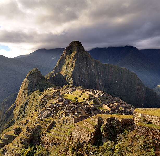
By far the best example of Inca architecture is the breath taking site of Machu Picchu:  
Machu Picchu, Image courtesy of Martin St-Amant, Wikipedia Commons
Inca buildings were constructed of white granite or limestone. The temples were constructed without any use or mortar because the stone block fit together so perfectly. The stones that were used fit together because they were sculpted by repeatedly lowering a rock onto another rock and carving away any sections on the lower rock. Another technique used was narrowing of the top than at the bottom of walls of temples and palaces. They are not perpendicular but slope slightly inward. The doors of Inca houses were usually high and trapezoidal shape. As in ancient Egypt, the bottom of the door is wider than the top.
Pictures of the exterior wall of the Inca fortress of Sacsayhuaman, showing how the huge pieces of rock fit perfectly.
Image courtesy of Christophe Meneboeuf, Wikipedia Commons 
Stone wall, Image courtesy of Rutahsa Adventures
Doorway, Image courtesy of Lonely Planet Images

Social Order and Politics
The social order of the Inca varied from area to area, but it maintained the same basic structure. On top were the Sapa Inca. Inca translates to emperor, sapa means only - so Sapa Inca means "Only Ruler". Then came the nobles, these were often the priests and relatives of past emperors or the current ones. After, there were craftsmen and architects; they were very high on the social ladder because of their skills valued by the Empire. Then came the working class, often just farmers. After this, were the slaves and peasants of the society.
Inca empire expansion
Image courtesy of Spesh531, Wikipedia Commons
When the Chancas attacked, in the early 15th century, and Cusi Yupanqui took over his father's throne, Viracocha Inca, he managed to put the empire back together under the name of Pachacuti in alliance with his son Tupac Inca. With this, Tawantinsuyu was born.
"Through threat, negotiation, or actual bloody conquest, they subjugated new provinces, determined the number of tax-paying peasants, installed a local Inca governor, and then left an administration in place that was empowered to supervise and collect taxes before armies moved on. If cooperative, the local elites were allowed to retain their privileged positions and were rewarded handsomely for their collaboration. If uncooperative, the Incas exterminated them and wiped out their supporters. Peasants were a crop, a crop that could be harvested through periodic taxation. Docile, obedient workers who created surpluses, in fact, were more valuable than any of the ...potatoes...llamas...and alpacas..." - Kim MacQuarrie, "The Last Days of the Incas," pg. 45


Gold figurines, Image courtesy of Geyman.com
Art
The Inca sculpted pottery and ceramics which featured geometric designs painted in black, red, brown, yellow, and white. Metalworkers excelled making ornaments, tools, and weapons out silver, copper, gold, and bronze. Female statues are found with Inca offerings to the gods. Because llamas were very important in the Andean region, lots of stylized llama figures were made by metalworkers. 


Wooden llama, Image courtesy of lrb.com
Metal artwork is scarce. Spanish conquistadores took it upon themselves to melt down as much gold and silver as possible to send back to Spain. 

The Mystery of Machu Picchu
On July 24, 1911, Hiram Bingham (with the help of local Indians) stumbled upon what he believed was Vilcabamba, the lost city of the Inca where the last of the independent Inca rulers waged a years-long battle against the Spanish -- but what he found was not the lost city, but a forgotten city.

Since the Inca did not develop a writing system (they used a knotting system known as the quipu), they did not leave behind any documented clues on what the purpose of the location was. Bingham had to rely on excavating to determine what Machu Picchu was. At first he had belived it was some kind of a training ground for women since most skeletal remains found was mostly female (later analysis proved it was fifty-fifty male and female). The latest accepted idea (2007) is that this marvelous city, in fact, was a royal estate of Pachacuti.
"To commemorate his conquest of the Vilcabamba Valley, Pachacuti ordered that his third royal estate be built, this one very near the Chuquichaca bridge, on a high ridge overlooking what is now called the Urubamba River. The Inacas apparently called the new site Picchu, meaning 'peak.' Since the proposed citadel and nearby satellite communities were planned from the start to form a part of a luxurious private estate, the entire complex would display some of the finest examples of Inca engineering and art. [...] The citadel of Machu Picchu was thus the third and perhaps the most important jewel in the crown of architectural monuments that Pachacuti had created, after Pisac and Ollantaytambo." - Kim MacQuarrie, "The Last Days of the Incas," pg. 441, 443
Excavation at Machu Picchu is still continuing but any further evidence regarding the purpose of the location is highly unlikely. The best clues scientist and archaeologist have is only the remains that can reveal the reasons for its construction, the activities that took place long ago on the peak along the Urubamba River.

Learn more about the Incas!
Here are our recommendations:
  

References:

Jones, David M. The Myths & Religion of the Incas. UK: Southwater, 2008.
MacQuarrie, Kim. The Last Days of the Incas. UK: Piatkus, 2007.
"National Geographic Photo Gallery--Inca Culture." National Geographic. Web. 08 Jan. 2012. 
Williams, Bill. "The Incredible Incas for Kids." The Incredible Incas for Kids. Web. 08 Jan. 2012. 


Profile-photo

About the Author


I'm Jose Pierre and I like learning about all aspects of culture, both ancient and modern. I enjoy learning how they communicated, expressed themselves, and their technology.

Civilizations Around the World: The Hittites

on 04 January 2012

The Hittites were a Bronze Age people from mountainous region of central Anatolia, modern Turkey. As powerful warlike people they battled constantly with the neighboring groups for control over the Mediterranean trade. The Hittites were forced to master a harsh homeland with land barely suitable to farm wheat and barley and domesticate sheep and cattle. Against the odds of the land and the success of their powerful army, the Hittites flourished between about 1600 and 1200BC, reaching its height in the 14th century.


Map of the Hittite Empire, courtesy of touregypt.net
The Hittite built a massive stronghold at Hattusas, the center of their kingdom. Here they recruited and trained their powerful army. Much of the military success of the Hittite came from their skill as charioteers. They among the first to use horses in warfare and developed the chariot as one of the most feared weapons in battle. Each of their chariots could hold up to three people, one to drive, and two to fight. Being an army centered group, the Hittites were almost constantly at war, either in order to claim and protect their territory from their neighbors. Most of what we know about them today comes from ancient texts that have been recovered from ancient cuneiform letters and clay tablets. The greatest contract, or at least the most extensively documented contact, was between the Hittites and the Egyptians. They made treaties with the Egyptian pharaohs to avoid any conflicts (the Hittites sometimes bought off their rivals with gold) and were documented on clay tablets and found in the massive royal archives at Hattusas.

Cuneiform, image courtesy of historicconections.web.com
Cuneiform, image courtesy of biblearchaelogy.org
One of the well-known remains of the Hittites is their lion gates. They were the fearsome lion decorated stone gateways of Hattusas. Their capital city was well protected from enemies because it was set among cliffs and mountains, and the lions appeared to be life-like as the capitals guardians. 

The Lion Gate, image courtesy of anthroarcheart.org
Although the Hittites had a strong land army, it was difficult for them to defend their coasts. Invaders from the sea, known to them as “sea peoples”, constantly attacked the Hittites. This, together with unreliable harvests and constant pressure from the Egyptians, eventually bought the empire crumbling down in 1200BC.


Profile-photo

About the Author


I'm Jose Pierre and I like learning about all aspects of culture, both ancient and modern. I enjoy learning how they communicated, expressed themselves, and their technology.

Civilizations Around the World: The Khmers

on 14 December 2011


The Khmer empire flourished during the 9th to the 15th centuries in Southeast Asia. Kingdoms of the Khmer at times ruled over and/or controlled parts of modern-day Laos, Thailand, Burma, and Cambodia. Its greatest legacy is Angkor, the site of the capital city during the empire's zenith. Angkor contains several testimonies to the Khmer empire's immense power and wealth, as well as the variety of belief systems that it patronized over time. The empire's official religions included Hinduism and Mahayana Buddhism, until Theravada Buddhism prevailed, even among the lower classes, after its introduction from Sri Lanka in the 13th century. Modern researches by satellites have revealed Angkor to be the largest per-industrial urban center in the world.


The end of the Angkor period happened during the 13th and 14th centuries. By the 15th century all of the inhabitants of Angkor had abandoned the kingdom, except Angkor Wat, which is a Buddhist shrine. Some of reasons on why are:
  • War with the Ayutthaya kingdom, Khmer capital abandonment was caused because of ongoing   wars with the Ayutthaya invaders. Since the entire population was obligated to participate, the kingdom was completely devastated by such wars.
  • Natural disasters such as earthquakes and drastic climate changes caused water shortages 


The great temples of ancient Khmer remained largely cloaked by the forest. The few sites that are exposed are being maintained by archaeologist. Every year tourist come to see the great sites and is good for the economy but a little bothersome for the sites. Tourism to Angkor has increased significantly in recent years, with visitor numbers reaching 900,000 in 2006; this poses additional conservation problems but has also provided financial assistance to the restoration effort:
  • Water-table dropping, With the increased growth in tourism at Angkor, new hotels and restaurants are being built to accommodate such growth. Each new construction project drills underground to reach the water table, which has a limited storage capacity. This demand on the water table could undermine the stability of the sandy soils under the monuments at Angkor, leading to cracks, fissures and collapses.
  • Looting, Looting has been an ever-growing threat to the Angkor archaeological landscape. According to APSARA, the official Cambodian agency charged with overseeing the management of Angkor, "vandalism has multiplied at a phenomenal rate, employing local populations to carry out the actual thefts, heavily armed intermediaries transport objects, often in tanks or armored personnel carriers, often for sale across the Cambodian border."
  • Unsustainable tourism, The increasing number of tourists, which the Cambodian government hopes will reach three million by 2010, exerts pressure on the archaeological sites at Angkor by walking and climbing on the (mostly) sandstone monuments at Angkor. This direct pressure created by unchecked tourism is expected to cause significant damage to the monuments in the future.
The Khmer kingdom lasted for over 500 years and occupied much of modern Cambodia and Vietnam. As the largest pre-industrial urban center in the world, and for its fascinating architecture, it is important that we conserve its remains so future generations can look back and ponder about their ancestors.

Profile-photo
About the Author


I'm Jose Pierre and I like learning about all aspects of culture, both ancient and modern. I enjoy learning how they communicated, expressed themselves, and their technology.

Civilizations Around The World: Gobekli Tepe

on 16 November 2011


Gobekli Tepe is pre-historic site that was built roughly twelve thousand years ago.  The site is located southeastern Turkey in the town of Sanliurfa. Its excavations began in 1995 by Professor Klaus Schmidt with the help of the German Archeological Institute. Archaeological findings have proposed that Gobekli tepe was used for religious or ritual purposes. Gobekli Tepe is said to be the oldest human-made site/structure yet to be discovered.

 One of the things Gobekli Tepe is known for is its giant T-shaped monolithic stone pillars or statues made of limestone. Height of the stones range from 3 to 6 meters and weigh from 40 to 60 tons. How and why these giant stones were erected is still a mystery.

How they were erected?

Scattered throughout the site and depicted on the pillars are abstract symbols and relief’s of foxes, lions, cattle, snakes, wild boars, cranes, ducks. Most of these were carved into the flat surfaces of these pillars and others are three-dimensional sculptures for example a shape of a lion, descending on the side of a T-pillar.


Gobekli Tepe is another long forgotten civilization that had advanced knowledge. Who they were or what they looked like is still a mystery. Five percent of the site has only been excavated, so it will be about another fifty years until any major findings that can help explain who the people of Gobekli Tepe were.  


Profile-photo
About the Author


I'm Jose Pierre and I like learning about all aspects of culture, both ancient and modern. I enjoy learning how they communicated, expressed themselves, and their technology.

Civilizations Around the World: The Indus Civilization

on 09 November 2011

The Indus Civilization
Mohenjo-Daro

About 4500 years ago, while in Egypt the pyramids were being built and scripture was being written Mesopotamia, in the great Indus Valley, todays Pakistan, the great city of Mohenjo-Daro was being constructed. Mohenjo-Daro, or “Mound of The Dead”, was one of the world’s largest and earliest urban settlements of the ancient Indus Valley civilization. It was built around 2600 BC and was abandoned 1800 BC. The site consisted of a planned layout based on a rectangular grid. Buildings were made of fired and mortared brick, others with mud-brick and some wooden structures. The city was rebuilt several times, over each other, due to floods from the Indus River.  
The great size and grid arrangement of the city suggested that Mohenjo-Daro was a made with a high level of social organization. At its peak, Mohenjo-Daro could have supported a population around 35,000. The city was then separated into two sections, the citadel and the lower city. The Lower City is yet to be uncovered, but the Citadel is famous for its large public baths or pools, a large residential structure that could house up to 5,000 citizens, and two large assembly halls, the Pillared Hall and the College Hall

The Great Granary was a massive structure built with solid brick foundations with sockets for a wooden super structure and doorways. The function of the Granary has not been determined because of the improper excavations done by local workmen, and no proper documentation of precise location of artifacts. The structure was probably a large public location, a storehouse, or a temple of some form.

North east of the Great Granary is a large and elaborate public bath called the Great Bath. From a colonnaded courtyard, steps lead down to the brick-built pool, which was waterproofed by a lining of bitumen. The pool measures 12m long, 7m wide and 2.4m deep. The baths may have been used for religious purification.

Great Bath
The Pillared Hall is thought to be an assembly hall of some kind. And the College Hall was a complex structure that contained over 70 rooms that is believed to house residence of upper class.

The city’s central marketplace contained a large central well. Individual households or groups of households obtained their water from smaller wells. Waste water was channeled in drains that lined the major streets. Some houses of the wealthier inhabitants included rooms that appear to have been used for bathing. One building had an underground furnace (known as a hypocaust)that was possibly used for heated bathing. Most houses had inner courtyards, with doors that opened onto side-lanes. Some buildings had two stories.

One of the well-known artifacts found in Mohenjo-Daro is a small steatite figurine of a priest-king:


The sculpture has two small holes under its ears and suggests it might have been worn as a necklace or a kind of ornament. The priest king is wearing a robe with an exposed shoulder, headband and an armband that has a small ring attached to it. Although there is no evidence that mohenjo-daro was a ruled by monarchs or priests, archaeologist suggest that the figuring is a preist king due to its appearance.  

Questions still being asked today include “who were the people who constructed this great and organized city?”, “why did they abandoned the city and what happened to the inhabitants?”


Profile-photo
About the Author


I'm Jose Pierre and I like learning about all aspects of culture, both ancient and modern. I enjoy learning how they communicated, expressed themselves, and their technology.

What's the deal with all the dates?!

on 10 October 2011

Dating Techniques by Jose-Estrada and Melanie Magdalena


There are many dating techniques used in the scientific world. Archaeologists, geologists, and paleontologists use dating techniques to determine the age and time frames for civilizations, geologic patterns, and organisms. There are two main types: relative and absolute. Relative dating is abstract while absolute dating requires lab tests... (and money!)

RELATIVE DATING
In simple English, relative dating is using geologic record to find out just how old a rock or artifact is by using the surrounding context. These are not calendar dates, basically what is closer to the surface is younger than what is under the surface. Archaeologists use several techniques to develop a chronological sequence to order styles, types, and assemblages. Geologists also use different relative dating techniques to identify different rock layers; paleontologists date fossils using geologic record.

Relative Dating Techniques:

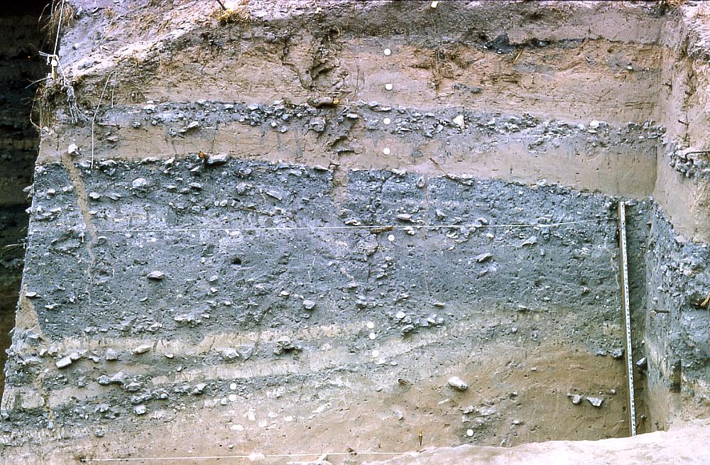
  • The Law of Superposition or Steno’s law is the principle that each bed of sedimentary rock is older than the layers above and younger than the layers below. This concept of rock layers is also known as stratigraphy. An example of stratigraphy is the Arenosa shelter in Texas.
  • Index Fossil Concept is the idea that similar fossils are of similar age or limited to a time span.
  • Time-Markers are artifacts that are proven to be from a particular period of time.
  • Seriation is a change of style, usually in artifacts. as new technologies arise they replace the older over time. Seriation does not tell us the age of a site, it only tells us if a site is older or younger than another based on the style of artifacts.
Arenosa Shelter, Lower Pecos Canyonland
Index fossils and seriation
ABSOLUTE DATING

Absolute dating “provides calendar reference to dates” (Shafer 2007). There are multiple techniques for absolute dating, some can be used for multiple types of samples while others are specialized.

Absolute Dating Techniques:

  • Dendrochronology, or tree ring dating, uses the annual growth rings in trees to assign a calender age to ancient wood. Tree-ring dating was developed by astronomer A. E. Douglass based on the principle that moisture varies from year to year - this moisture ratio is preserved in trees making trees an effective climate change map. One ring is developed each year, the color intensity (light/dark) can distinguish if it was formed in the spring/summer (light ring), or in the summer/fall (dark ring). By combining dendrochronology samples with radiocarbon dates, tree rings have revealed atmospheric changes and the changes in Carbon-14 quantities. A mathematical formula is applies to radiocarbon dates to make up for these fluxes.
  • Radiocarbon Dating is only good for organic remains that are younger than about 45,000 years old. Willard Libby developed this technique based on the fact every living thing absorbs the radioactive Carbon 14 (C-14) isotope. C-14 is produced in the atmosphere by cosmic rays and every living thing breathes in Carbon from the atmosphere. When an organism is alive it maintains equilibrium of ^14C. When it dies its C-14 count begins to decay. The amount of C-14 halves every 5,730 years (half-life) after the death of the organism. Carbon-14 is commonly measured in two ways:

    1. Conventional Radiocarbon Dating uses a Geiger counter and measures the beta particle emission from a sample. The slower the emission rate, the older the sample. This method is destructive and requires a twenty-five gram sample at the very least.
    2. Accelerator Mass Spectrometry (AMS) is a method of Radiocarbon dating that directly counts the proportion of carbon isotopes in samples of one gram or less. Compared to conventional radiocarbon dating, AMS requires less material and is also non-destructive (meaning the sample can be kept after the dating test).

  • Trapped Charge Dating is based on the fact electrons become trapped in mineral crystal lattices due to background radiation. The total amount of radiation the specimen received is divided by the annual dose of radiation. There are three sub-dating techniques for trapped charge dating:
    1. Thermoluminescence (TL) is used to date ceramics and burned stone artifacts. TL measures the total radiation dose of a artifact by heating the specimen to 500 degrees centigrade. the trapped electrons in quarts or feldspar crystals move back to their orbits, releasing energy in the form of light. the amount of light released gives the needed measurement of total radiation dose, which is then divided by the annual dose of radiation.
    2. Optically Simulated Luminescence (OSL) is used to date dirt by determining last time it was exposed to sunlight. It is measured by passing a light of particular wavelength over the sample, the trapped electrons go into orbit again emitting their own light; the intensity of the light reveals the total radiation measurement. soil samples must be collected carefully and cannot be exposed to sunlight.
    3. Electron Spin Resonance (ESR) is used to date tooth enamel. tooth enamel contains hydroxyapatite, which does not trap charges when formed. Once the tooth is deposited in the ground, it starts to a accumulate background radiation. The tooth is exposed to electron magnetic radiation and the amount that it absorbs is proportional to it total radiation dose.  
  • Argon-Argon Dating is used to date volcanic ashes to when they they were erupted that are between 500,000  and several million years old. Argon-Argon dating measures the ratio of argon-39 and argon-40 in volcanic ashes. This dating technique only requires a small sample.
Tree rings
An example of Radiocarbon dating
So now the mystery of dating techniques has been solved. Different types of dating are used for different situations and different types of finds. Every scientist has their own favorite, but now you can go out and make rough estimates for your finds!

References:
Kelly, Robert L. and David Hurst Thomas. (2010) Archaeology (5th ed.). Belmont, CA: Wadsworth/Cengage Learning.
Shafer, Harry J. (2007) Archaeology 101. Texas Archaeological Academy.

Share This

Never miss an article, subscribe here!

Credits & Policies

Banner created by Melanie Magdalena.

Images courtesy of: Ricardo Liberato (Pyramids of Giza), Aurbina (Moai), Maria Reiche (Nazca), Zunkir (Gobekli Tepe), Bjorn Christian Torrissen (Chichen Itza), Gareth Wiscombe (Stonehenge).

Images were released to the public and/or licensed under Creative Commons.

Editor's Note

Welcome to BermudaQuest, a free online journal primarily about Archaeology, Ancient History, and stories about different cultures from around the world.

Founded by Melanie E Magdalena, BermudaQuest and Origins (our magazine) have over a million readers! We would love to include your insight, experience, photos, and thoughts about your culture, heritage, and travels. Make sure you check out Origins, with over 4 million readers!