Showing posts with label Exploring. Show all posts

Exploring Southern Utah's National Parks

on 30 September 2012

There’s a lot hidden in the wild spaces of the world, and few are wilder than the deserts and canyons of Southern Utah. Within a few hundred miles, you can visit a handful of National Parks. There are few places in the world where you can see such a variety of stunning landscapes in one region. Such is the diversity of the American Southwest. You could spend a lifetime exploring these parks, but if you only have a short time, be sure to hit these highlights.

Arches


Over 2,000 naturally formed stone arches dot the landscape throughout the sparse landscape of this park near Moab, Utah. Most of this region of the Southwest was covered by Lake Bonneville millions of years ago, and the rushing waters left behind stunning rock formations and shapes that are reminiscent of underwater landscapes.

Delicate Arch, Arches National Park, Utah | PD-US

Delicate Arch is probably the most recognizable of the arches, but it’s actually quite solitary. You’ll see more arches on shorter hikes in Devil’s Garden, with the very impressive Landscape Arch stretching an insane span. Drive the scenic loops to get to the trailheads and get great photo ops in this alien landscape.

Canyonlands


Canyonlands National Park is characterized by the gorgeous canyons, buttes and other rock formations that surround the Colorado River. The most shocking site there has to be The Needles at the Southeast corner of the park, filled with multicolored rock spires that look like nothing you’ve ever seen. In the park, you’ll also find sites like The Maze and the Island in the Sky, both of which offer special formations and seemingly endless trails to hike.

Grand Staircase and Escalante


Many of Southern Utah’s paleontological sites are clustered in Escalante National Monument and Grand Staircase. A diverse sample of Southern Utah landscapes all in one park that spans nearly 2 million acres. If you want to see the various ecosystems, wildlife and flora that have made their niche in the deserts, canyons and riverbeds of this region, make some time to wind your way through the trails of this area.

Bryce Canyon


You’ve never seen vistas like these. The world opens up when you stop at any of the scenic overlooks that fill the park. The horizon just seems to fall away as the massive sky falls to meet the huge open spaces that are often hidden by rock faces and canyon walls. You can actually see the curvature of the earth in some places around Bryce. This is the perfect part to drive through, and you’ll still find plenty of places to hike.

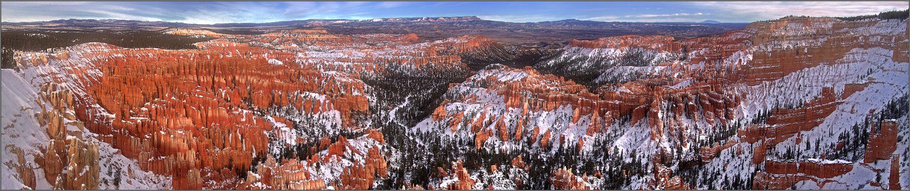
Bryce Canyon National Park, Utah | Gernot Keller, Wikimedia Commons

Zion


Angel’s Landing is one of the hardest hikes you’ll ever go on, and it’s not for the faint of heart, but it also provides one of the most amazing views in the park, not to mention the Western United States. More advanced hikers may want to take a guided tour through The Narrows, a trek through the ever closer canyon walls and sheer cliff faces. It’s possibly one of the most visually appealing and incredible hikes in the entire National Park system.


About the author: Rachel Phelps loves getting up early for a pre-dawn hike to hear the sound of the wilderness waking up. If you’ve ever seen the sun rise over the desert, you’ll know how she feels. You can find her writing about her travel experiences and favorite camping spots at PleasureTripping.com.

Cosquer Cave

on 24 February 2012

Cosquer Cave
Image courtesy culture.gouv.fr
Cosquer Cave is located at Cape Morgiou, in the Calanques (Calanques are limestone cliffs very steep and with very deep waters with steep and dangerous shores), near Marseilles. It can be accessed through a tunnel 175 metres in length, which is 37 metres under the sea level due to the rise of the Mediterranean in Paleolithic times. It was discovered by diver Henri Cosquer in 1985, but its contents were not made public until 1991, when three divers became lost in the cave and tragically died.

In 1991 Cosquer made his fifth attempt to reenter with a new batch of experienced divers from his own club. This time they entered the other lake; from there Cosquer noticed an image of a human hand on the walls and was photographed. Reaching home when the films were developed he could notice two more hands and a feeling that they have bumped upon something marvelous began to haunt them. If Cosquer was not lucky enough to notice the ‘hand’ and the outside world would never have come to know about this prehistoric treasure that existed.

Stencil of a human hand dated 27,000 BCE, 
shown at the Musée d'Archéologie Nationale
(National Museum Archeology)
in Saint-Germain-en-Laye, France
The most unique feature of this cave is that it contains several dozen works painted and engraved between 27,000 and 19,000 years ago, decorated with a variety of land animals, penguins, cats, and engravings on the walls, but also with seals and auks, fifty-five hand stencils, and numerous digital markings, dozens of geometric symbols, as well as the extraordinary representation of a "slain man".


Caves were the initial homes of men and he could not but give expression to his artistic talents on its walls during resting or idle times may be the usual concept of the images those appear on the walls of caves. But David Lewis Williams states that there is a pattern in the carvings and images on the walls of caves and that would not have done as a time pass. His studies based on ethnography pictures of things happened in the ‘Cro-Magnon arts in the following pattern.


References:

"Cosquer Cave" - Accessed on 25 January 2012


Profile-photo
About the Author


I'm Jose Pierre and I like learning about all aspects of culture, both ancient and modern. I enjoy learning how they communicated, expressed themselves, and their technology.

What's the deal with all the dates?!

on 10 October 2011

Dating Techniques by Jose-Estrada and Melanie Magdalena


There are many dating techniques used in the scientific world. Archaeologists, geologists, and paleontologists use dating techniques to determine the age and time frames for civilizations, geologic patterns, and organisms. There are two main types: relative and absolute. Relative dating is abstract while absolute dating requires lab tests... (and money!)

RELATIVE DATING
In simple English, relative dating is using geologic record to find out just how old a rock or artifact is by using the surrounding context. These are not calendar dates, basically what is closer to the surface is younger than what is under the surface. Archaeologists use several techniques to develop a chronological sequence to order styles, types, and assemblages. Geologists also use different relative dating techniques to identify different rock layers; paleontologists date fossils using geologic record.

Relative Dating Techniques:

  • The Law of Superposition or Steno’s law is the principle that each bed of sedimentary rock is older than the layers above and younger than the layers below. This concept of rock layers is also known as stratigraphy. An example of stratigraphy is the Arenosa shelter in Texas.
  • Index Fossil Concept is the idea that similar fossils are of similar age or limited to a time span.
  • Time-Markers are artifacts that are proven to be from a particular period of time.
  • Seriation is a change of style, usually in artifacts. as new technologies arise they replace the older over time. Seriation does not tell us the age of a site, it only tells us if a site is older or younger than another based on the style of artifacts.
Arenosa Shelter, Lower Pecos Canyonland
Index fossils and seriation
ABSOLUTE DATING

Absolute dating “provides calendar reference to dates” (Shafer 2007). There are multiple techniques for absolute dating, some can be used for multiple types of samples while others are specialized.

Absolute Dating Techniques:

  • Dendrochronology, or tree ring dating, uses the annual growth rings in trees to assign a calender age to ancient wood. Tree-ring dating was developed by astronomer A. E. Douglass based on the principle that moisture varies from year to year - this moisture ratio is preserved in trees making trees an effective climate change map. One ring is developed each year, the color intensity (light/dark) can distinguish if it was formed in the spring/summer (light ring), or in the summer/fall (dark ring). By combining dendrochronology samples with radiocarbon dates, tree rings have revealed atmospheric changes and the changes in Carbon-14 quantities. A mathematical formula is applies to radiocarbon dates to make up for these fluxes.
  • Radiocarbon Dating is only good for organic remains that are younger than about 45,000 years old. Willard Libby developed this technique based on the fact every living thing absorbs the radioactive Carbon 14 (C-14) isotope. C-14 is produced in the atmosphere by cosmic rays and every living thing breathes in Carbon from the atmosphere. When an organism is alive it maintains equilibrium of ^14C. When it dies its C-14 count begins to decay. The amount of C-14 halves every 5,730 years (half-life) after the death of the organism. Carbon-14 is commonly measured in two ways:

    1. Conventional Radiocarbon Dating uses a Geiger counter and measures the beta particle emission from a sample. The slower the emission rate, the older the sample. This method is destructive and requires a twenty-five gram sample at the very least.
    2. Accelerator Mass Spectrometry (AMS) is a method of Radiocarbon dating that directly counts the proportion of carbon isotopes in samples of one gram or less. Compared to conventional radiocarbon dating, AMS requires less material and is also non-destructive (meaning the sample can be kept after the dating test).

  • Trapped Charge Dating is based on the fact electrons become trapped in mineral crystal lattices due to background radiation. The total amount of radiation the specimen received is divided by the annual dose of radiation. There are three sub-dating techniques for trapped charge dating:
    1. Thermoluminescence (TL) is used to date ceramics and burned stone artifacts. TL measures the total radiation dose of a artifact by heating the specimen to 500 degrees centigrade. the trapped electrons in quarts or feldspar crystals move back to their orbits, releasing energy in the form of light. the amount of light released gives the needed measurement of total radiation dose, which is then divided by the annual dose of radiation.
    2. Optically Simulated Luminescence (OSL) is used to date dirt by determining last time it was exposed to sunlight. It is measured by passing a light of particular wavelength over the sample, the trapped electrons go into orbit again emitting their own light; the intensity of the light reveals the total radiation measurement. soil samples must be collected carefully and cannot be exposed to sunlight.
    3. Electron Spin Resonance (ESR) is used to date tooth enamel. tooth enamel contains hydroxyapatite, which does not trap charges when formed. Once the tooth is deposited in the ground, it starts to a accumulate background radiation. The tooth is exposed to electron magnetic radiation and the amount that it absorbs is proportional to it total radiation dose.  
  • Argon-Argon Dating is used to date volcanic ashes to when they they were erupted that are between 500,000  and several million years old. Argon-Argon dating measures the ratio of argon-39 and argon-40 in volcanic ashes. This dating technique only requires a small sample.
Tree rings
An example of Radiocarbon dating
So now the mystery of dating techniques has been solved. Different types of dating are used for different situations and different types of finds. Every scientist has their own favorite, but now you can go out and make rough estimates for your finds!

References:
Kelly, Robert L. and David Hurst Thomas. (2010) Archaeology (5th ed.). Belmont, CA: Wadsworth/Cengage Learning.
Shafer, Harry J. (2007) Archaeology 101. Texas Archaeological Academy.

Exploring: Henges

on 29 December 2010

Share This

Never miss an article, subscribe here!

Credits & Policies

Banner created by Melanie Magdalena.

Images courtesy of: Ricardo Liberato (Pyramids of Giza), Aurbina (Moai), Maria Reiche (Nazca), Zunkir (Gobekli Tepe), Bjorn Christian Torrissen (Chichen Itza), Gareth Wiscombe (Stonehenge).

Images were released to the public and/or licensed under Creative Commons.

Editor's Note

Welcome to BermudaQuest, a free online journal primarily about Archaeology, Ancient History, and stories about different cultures from around the world.

Founded by Melanie E Magdalena, BermudaQuest and Origins (our magazine) have over a million readers! We would love to include your insight, experience, photos, and thoughts about your culture, heritage, and travels. Make sure you check out Origins, with over 4 million readers!