Showing posts with label Field Work. Show all posts

Site Formation Processes

on 03 February 2012

There are two recognized site formation processes that help answer archaeologists’ questions about where dirt came from, if objects were made by humans, and why ancient people left the objects behind. The first is cultural, where the formation agent is cultural activity, and the second is noncultural or environmental, where the agent is a natural environment process. 

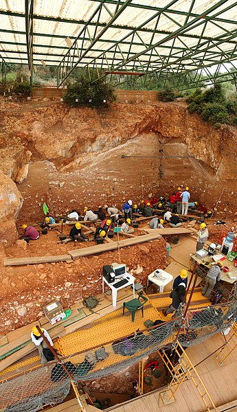
Excavations at the site of Gran Dolina, in Atapuerca (Spain), during 2008. Panoramic photography formed using 3 individual photographies with Hugin software. TD-10 archaeological level is being excavated where the most of the people are. It is a Homo heidelbergensis camp. Under the plank, we can observe a woman with red sweatshirt excavating TD-6 archaeological level, where were found the first remains of Homo antecessor.
Image and description courtesy of Mario Modesto Mata, Wikipedia Commons
There are four major cultural formation processes. The first is reuse, the process of recycling or remanufacture, secondary use or no remanufacture, and lateral cycling or a change in user. The second is cultural deposition, the change or transformation of cultural materials from a behavior context to an archaeological context via discard, accidental loss, ritual deposition, abandonment of artifacts and structures. The third is reclamation, the process of removing items from the archaeological context to a systemic context by scavengers, collectors, and looters, reoccupation of sites, reincorporating artifacts and structures, and archaeological recovery. The fourth is disturbance, processes that alter the ground, such as digging and plowing, and modifying archaeological materials and sites.

Natural formation processes can by biological, chemical, or physical processes of the natural environment and are observed on three major scales. The first, artifact-scale processes, includes rotting, corrosion, and sandblasting that weathers, deteriorates, or decays materials. The second, site-scale processes, are deposit disturbances by tree roots and burrowing animals. The third, regional-scale processes, is the burial or erosion of sites due to water or wind sediment deposits and vegetation.

Understanding site formation processes is necessary so that the archaeologist can read the exact context of the artifact and/or structure being analyzed in order to interpret the exact history of a site. By understanding how these can be altered, an archaeologist can recreate the original in its proper context without the alterations. Archaeologists can pick out modified tools from original discarded tools as well as hunted animal bones from wild animal bones.


Profile-photo
About the Author


I'm Melanie, the founder of BermudaQuest and an archaeology undergraduate at the University of New Mexico. I love writing about ancient and modern cultures. My goal is to make information about our origins available to everyone [in simple English!]

Chronological Methods: Obsidian Hydration Dating

on 29 January 2012

Obsidian Flake
Copyright: Melanie Magdalena
Volcanic glass is known as obsidian. Humans in the past often used obsidian as a raw material when making chipped stone tools like arrowheads and spear points. Obsidian is formed by the rapid cooling of silica rich lava. Its precise chemical composition often varies from one outcrop to another, but it always contains seventy percent silica by weight.

Geologists Irving Friedman and Robert Smith, investigated obsidian's potential as a time marker. They introduced the obsidian hydration dating method to the archaeological community in 1960. It may be used in two ways: as a relative dating method to determine if one artifact is older or younger than another, or as an absolute dating method where a calendar date (AD/BC) is produced. The decision to use it as a relative or absolute dating method depends upon whether the environmental conditions of the archaeological site are known.

How does obsidian hydration dating work? Obsidian contains about 0.2 percent water. When a piece of obsidian is chipped and exposed to atmospheric water, it attracts the water to the surface and begins to diffuse into the glass. The result is the formation of a water rich hydration rind that increases in depth with time. The hydration process continues until the fresh obsidian surface contains about 3.5 percent water, this is the saturation point. The thickness of the hydration rind can be identified in petrographic thin sections cut normal to the surface and observed under a microscope. Friedman and Smith reasoned that the degree of hydration observed on an obsidian artifact could tell archaeologists how long it had been since that surface was created by a flintknapper.

There are some limitations to dating using obsidian hydration. Hydration forms at different rates on different obsidians. The rate of hydration can differ throughout the world. Soil temperature and relative soil humidity need to be well estimated. It is best to use a sample with known age and similar composition to the sample being dated.

Another limitation is that an artifact, for example, a tool that was used to skin a deer is used and then discarded. Several hundred years later, a second individual finds the tool and sharpens it and uses the refurbished tool for a completely different use - like to shave bark of a tree. When the archaeologists finds it in a site and sends it to be dated, instead of dating the surface that was used to shave bark, the surface that was used to skin deer is dated, giving an erroneous date for the site it was in.

References:
"Obsidian Hydration Dating." Accessed on 25 January 2012.


Profile-photo
About the Author


I'm Jose Pierre and I like learning about all aspects of culture, both ancient and modern. I enjoy learning how they communicated, expressed themselves, and their technology.

Handheld GPS: The Archaeologist Lifesaver

on 04 November 2011

While an archaeologist is conducting a field survey they typically rely on paper maps and compass to track their location or map a site. As technology advances the growing use of handheld GPS units is increasing because of their advanced capability to record data with near perfect precision. A GPS unit can help navigate by recording way-points so one can see how far they have traveled and can even retrace their steps using the way-points. Other useful features can include preloaded maps of areas with turn by turn navigation, measuring elevation, and built in compass.

I personally used the Garmin 60CSX handheld GPS on my trip to Belize. At first the interface was a bit confusing with cartoony icons but with just a few exercises with the unit I was able to navigate the menus and locate the various features it offered. During site exploration I was able to record my exact location within the sites and record the distance traveled between sites using the waypoints.

An example of how I used the GPS unit was to measure the distance of a nearby water source at the Mayan site Altun Ha. A fellow colleague paced the distance while I watched the distance traveled on the GPS. Pacing is a simple way to get an estimate for distance. By doing a sample pace test, I determined that ten meters equaled eleven and a half paces. Once we finished calculating the distance we compared our numbers and found that they were only off by a few meters. The GPS unit can give measurements with plus or minus five meters. 

My project in Belize was to determine if their was a certain characteristic in living spaces. I used the GPS to measure the dimensions of the plazas and the space inside the rooms on top of structures. Based on these calculations, I was able to conclude that most living spaces followed a Mesoamerican style of how space is used, structures or living quarters are spread out within their limitations.

Handheld GPS devices are useful tools that can be used in many ways. An improvement that everyone would like is a more precise distance and elevation measurement and a increased signal with the satellites up above. So far, only the military posses the more precise units but eventually they should be available to the public at a reasonable price.


Profile-photo
About the Author


I'm Jose Pierre and I like learning about all aspects of culture, both ancient and modern. I enjoy learning how they communicated, expressed themselves, and their technology.

Share This

Never miss an article, subscribe here!

Credits & Policies

Banner created by Melanie Magdalena.

Images courtesy of: Ricardo Liberato (Pyramids of Giza), Aurbina (Moai), Maria Reiche (Nazca), Zunkir (Gobekli Tepe), Bjorn Christian Torrissen (Chichen Itza), Gareth Wiscombe (Stonehenge).

Images were released to the public and/or licensed under Creative Commons.

Editor's Note

Welcome to BermudaQuest, a free online journal primarily about Archaeology, Ancient History, and stories about different cultures from around the world.

Founded by Melanie E Magdalena, BermudaQuest and Origins (our magazine) have over a million readers! We would love to include your insight, experience, photos, and thoughts about your culture, heritage, and travels. Make sure you check out Origins, with over 4 million readers!