Showing posts with label Civilizations. Show all posts

Land of the Cloud People

on 10 December 2012

Chachapoyas, in northern Peru, is the land of the “Cloud People.” This is the cloud forest of eternal mist, high in the Andes, overlooking the Amazon Basin, hidden in a perpetual mist with orchids and bromeliads everywhere. Though the Peruvian government thinks this area has the potential to become the “Machu Picchu of the north,” it has not yet reached that level of popularity, mainly because there are no commercial flights to the main city, also called Chachapoyas.

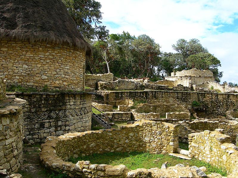
The most famous ruin is Kuelap. This fortress is the largest stone structure of South America. It contains more than 450 stone houses, mostly circular. It is located on a mountain higher than Machu Picchu, at 9500 feet, and is older than the Inca Empire. It was started at around 800 A.D. and was occupied until about 1500 A.D. It’s outer wall is about 700-800 yards long and ranges from 35 to over 50 feet high.

Kuelap, fortress of Peru
[José Porras, Wikimedia Commons, CC BY-SA 2.5]

There are many other unexcavated ruins on mountaintops in the area and new sites are always being found. Years ago, when I was hiking in the area with Dr. Peter Lerch, an officer from the Institute of Culture, he pointed to several mountaintops where you could faintly make out ruins. He knew they were there, but just hadn’t had time to investigate them because the only way to get to them was by foot or by horse. Once, when I was sending a group from Arizona to the area, my local operator told me that a new “lost city” had recently been discovered and wanted to know if my group would like to go there and be the first “gringos” to see the site. Naturally they said they would like to and it was one of the highlights of their trip.

Ruins at Kuelap
[Hanumann, Flickr, CC BY 2.0]

Snake Petroglyphs at Kuelap
[Ramtyns, Flickr, CC BY-NC 2.0]


Ruins of Chachapoya Dwellings
[Dave Lonsdale, Flickr, CC BY 2.0]

There are several cliff tomb sites such as La Petaca. Revash and Diablo Huasi and other citadels, such as Tajopampa and La Joya. The Chachapoyans practiced mummification. Several were found in La Petaca and many were found in the ruins at Laguna de Los Condores, which was discovered in 1996. A museum was built in Leymebamba to house the remains of the mummies and other artifacts that were found in the area.


Revash Mausoleum Tombs
[Pirindao, FlickrCC BY-NC-ND 2.0]

In the past few years, some of the highest waterfalls in the world, such as the Gocta waterfall have been found.

La Gocta Waterfall
[Martin St-Amant, Wikimedia Commons, CC BY-SA 3.0]

So, for those who like to visit exciting archeological places that are off the beaten path and away from the crowds, this is the place.


This guest contribution is by Jim McDaniel, Travel Innovations - Australian & Amazonian Adventures

The Lost Culture of the Mississippian Floodplain

on 06 August 2012

Before Columbus, one of the largest and sophisticated cities of America, rivaling even some of the largest cities in Europe, thrived on the floodplain of the Mississippi. This powerful culture influenced surrounding ones from the Great Lakes to the Gulf of Mexico. And then, suddenly, they all disappeared.

Entering the Cahokia Mounds State Historic Site, viewing Monk's Mound
[Northfielder/Flickr]

During the Mississippian period (800-1400 CE), Cahokia, located in southwest Illinois (just outside of St. Louis), had around 120 mounds which covered nearly 1,600 hectares. This is the largest pre-Columbian archaeological site in North America north of central Mexico, as well as the earliest. According to UNESCO, Cahokia is an exceptional example of pre-urban structuring. Also, "it is the pre-eminent example of a cultural, religious, and economic center of the prehistoric Mississippian cultural tradition." The size and layout of this pre-urban society is evidence of the powerful political and economic system that was in place, which can be held responsible for organization of labor, trade, and agriculture.

Cahokia was larger than London in 1250 CE. The Mississippians built a variety of structures: from practical homes to monumental public works that still remain. The agricultural society may have had a population of 10,000 - 20,000 at its peak (1050-1150 CE). And though this culture left us no writing, we have mounds.


Meet the Mounds


What They're Made Of


The Cahokia used earth and wood for their architecture. Examples of this can be seen in their mounds and in their homes. Wooden palisades encompassed many zones which were possibly defensive enclosures; this is seen at Monk's Mound and the entire central section of the site. Red ochre was found in postholes which may suggest that ochre was used as paint.

Monk's Mound & The American Woodhenge


Monk's Mound is the largest prehistoric earthwork in the Americas. It covers over 5 hectares and is 30 meters tall. This mound is where the leader of the community resided. In the early 1960s, Dr. Warren Wittry discovered a series of large oval-shaped pits, which later revealed fragments of red cedar (considered a sacred wood) that served as posts. Dr. Wittry named this Woodhenge. The posts mark the sunrises during the equinoxes with the front of Monk's Mound.

Monk's Mound
[reallyboring/Flickr]
Woodhenge
[Nathaniel Paluga (Drpaluga)/Wikimedia Commons CC-BY-SA 3.0]


Fox Mound & Round Top


The mounds known as Fox Mound and Round Top (also known as Moorehead's Mound) seem to have been joined by a platform (though, it's equally possible the mounds blended together over time). Fox Mound, at 14 meters tall, is a flat-top platform mound that has never been excavated. It's companion, Round Top, is a true conical mound about 13.4 meters tall which is also untouched. These two mounds retain much of their original forms today.

Fox Mound
[Lance and Erin/Flickr]
Round Top
[Lance and Erin/Flickr]
Fox Mound (left) and Round Top (right) as seen from the top of Monk's Mound
[jmehre/Flickr]

The Site Outskirts


Around the edges of the site lie the remains of resential quarters, areas for specialized activity, and public ceremonial areas. The living areas had small gardens, but the agricultural lands are found beyond the city-limits as well as small satelitte villages.

A diorama showing a Mississippian potter [LEFT] and woman grinding maize with a stone mortar [RIGHT],
from the Cahokia site museum.
[Herb Rose/Wikimedia Commons CC-BY-SA 3.0]


The Mystery of Cahokia

Where did the people of Cahokia go? Did other tribes absorb them? Did they create new tribes? Many questions remain unanswered about the Cahokians. The decline of their civilization may have begun around 1200 CE - we know that by the 1400s they were gone. Perhaps they depeleted their resources and were forced to move...war may have struck...maybe it was a disease. Political and economic power may have declined. We know they were a thriving community that made significant advances in astronomy, agriculture, and economics which probably spurred development in other regions of America.


Cahokia Today

Despite the four lane road that runs cuts through the site, Cahokia Mounds is one of eight cultural World Heritage sites in the United States. Ten miles away, only one mound remains. About 890 of the 1600 hectare site is protected. Of the 120 mounds, 109 have been recorded and 68 of those lie within the protective range of Cahokia Mounds State Historic Site. The rest lies under urbanization. Few know of the existence of Cahokia outside of St. Louis, IL. We may only see piles of dirt, but these piles of dirt tell one of the oldest stories of our American heritage.


For Further Reading


Cahokia Mounds State Historic Site :: www.cahokiamounds.org
Cahokia, America's Forgotten City (National Geographic) :: ngm.nationalgeographic.com
UNESCO Cahokia Mounds :: whc.unesco.org

Templo Mayor :: The Great Pyramid of the Aztec Empire

on 20 July 2012

Built upon Lake Texcoco, thousands of people flocked to the Great Pyramid. The inauguration of the latest reconstruction by Ahuitzotl occurred in the year 8 Reed (1487). Warrior after warrior captured in the Flower War climbed to the top to be sacrificied to the gods. Tlaloc and Huitzilopochtli would be pleased with their followers; blood flowed like a river down the endless staircase. But this was not the final bloodshed - the Spaniards were coming.

Scale model of the Great Pyramid at Tenochtitlan previously located at Templo Mayor museum. Currently on display at the Zocalo Metro Station. [Wikipedia/Wolfgang Sauber CC-SA-3.0]

Aztec ritual human sacrifice portrayed in the page 141
(folio 70r) of the Codex Magliabechiano.
[Wikipedia/Public Domain]
Flower Wars :: name given to the the battles fought between the city-states of the Triple Alliance: Tenochtitlan, Texcoco, Tlalcopan, and Huejotzingo. These ritual battles began during the reign of Moctezuma I when a great famine struck the land. Though many interpretations of the Flower Wars exist, the most popular idea is that these wars were a special institutionalized type of warfare used to satisfy the religious needs of the combatants. The warriors captured were honorably sacrificed for the good and welfare of their nation.
Many are familiar with the Aztec empire that flourished from 1325-1519, until the conquest led by Hernan Cortes. Their great capital, Tenochtitlan, was made possible by the cultural unity and political power of their time. But how is a city built on a lake?

Tenochtitlan began as a tiny marsh island in Lake Texcoco and was surrounded by chinampas - an agricultural system created by layering mud and vegetation in shallow parts of lakes. The city was connected to the mainland by three large causeways, which served as dikes - separating the city's freshwater from the surrounding salty waters. Chinampa canals helped convey traffic around the city.
Chinampa model at the Templo Mayor Museum
© Melanie Magdalena

Discovery


It wasn't until the 1900s when the temple was found in ruins. A waterway built tore through the site destroying even more of Mexico's ancient history. Mexico was well aware of the existence of the Great Pyramid; the Catedral Metropolitana (Metropolitan Cathedral) was purposely built on top of the site to enforce Catholicism on the Aztec people. The site visible today was excavated after in 1978.
Waterway constructed under the street Guatemala
in the 1900s © Melanie Magdalena

Understanding the Ruins


Today the Templo Mayor is open to the public. Much of its majesty and mystery remains buried at the heart of the Zocalo.

Taking that first step into the ruins sends you almost a thousand years back in time. Modern elevated paths take you through the site through its many phases of construction. What are these phases?
Templo Mayor cut-out. The ruins today are visible inside.
© Melanie Magdalena


Each ruler of Tenochtitlan was responsible for enlarging or expanding the Great Pyramid. Not only did the expansions reflect the growing population but may have been motivated by the constant floods the city suffered. These stages of construction are visible "thanks to" the conquest when the city was destroyed.

Templo Mayor and Coyolxauhqui monolith :: Stage IVb
Tlatoani, or lord of Tenochtitlan, Axayacatl expanded the main facade of the Great Pyramid at the beginning of his reign (1469-1481). Four serpent head sculptures were added next to the stairway. Today, two serpents can be seen (one included in the photo) with remains of their original coloring.  © Melanie Magdalena

Destruction of the Great Pyramid of Tenochtitlan

Tenochtitlan fell in 1521 and was almost completely destroyed. The Avila brothers, the conquerors, built their homes on top of the ruins. The brothers and Martin Cortes, son of Hernan Cortes, were arrested and sentenced to death in 1566 for conspiring against the Spanish crown.

For Further Viewing


Please visit our Google Plus album to view all of our photos of Templo Mayor taken during the MexiArch Project :: View album>>
Creative Commons License
MexiArch Project photos by Melanie E Magdalena are licensed under a Creative Commons Attribution-NonCommercial-ShareAlike 3.0 Unported LicensePermissions beyond the scope of this license may be available. Contact editor@bermudaquest.com for commercial permission.

For Further Reading


"Tenochtitlan." Columbia Encyclopedia. The Columbia Electronic Encyclopedia, Sixth Edition. Copyright © 2012, Columbia University Press. Licensed from Columbia University Press. All rights reserved. www.cc.columbia.edu/cu/cup/.


This article is part of the MexiArch Project (2012) by BermudaQuest

Sites Around the World: Jericho

on 06 March 2012

Jericho
Greatcommission.com
In the Old Testament, we have an account of the Israelites defeating the city of Jericho when they came into the Promised Land after wandering in the wilderness for 40 years. According to the biblical account, after the Israelites marched around the city once a day for six days, on the seventh day they encircled the city seven times. On the seventh time around, the priests blew the trumpets, the people shouted and the walls fell flat.

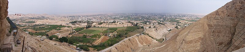
Charles Warren rediscovered these walls in 1868. Jericho, also known as present day Tell es-Sultan, is considered one of the oldest continuously inhabited cities in the world, with evidence of settlement dating back to 9000 BCE.

During the Natufian phase (10,800-8,500 BCE), sedentary hunter-gatherers lived in large semi-subterranean oval stone structures. By the Pre-Pottery Neolithic A phase (8,500-7,300 BCE) roofed, oval semi-subterranean dwellings appear as a village. During this time, the first tower was built along with a defensive perimeter wall. Inhabitants began engaging in long distance trade and growing domesticated crops. Plastered human skulls appear in rectangular houses with red- and white-painted floors during the Pre-Pottery Neolithic B phase (7,300-6,000 BCE). “Plastered skulls are a known trait from PPNB sites, such as Kfar HaHoresh, Beidha, Çatalhöyük and Beisamoun, and similar eerie statuary at 'Ain Ghazal” (Kris Hirst). 

Tell es-Sultan
Wikipedia Commons
By the Early Neolithic (6.000-5,000 BCE), Jericho was mostly abandoned. Throughout the Middle and Late Neolithic (5,000-3,100 BCE), there was very minimal occupation. Extra defensive walls and towers were added during the Early and Middle Bronze Age (3,100-1,800 BCE). In the Late Bronze Age (1,800-1,400 BC), Jericho is destroyed.
“The citizens of Jericho were well prepared for a siege. A copious spring which provided water for ancient, as well as modern, Jericho lay inside the city walls. At the time of the attack, the harvest had just been taken in (Joshua 3:15), so the citizens had an abundant supply of food. This has been borne out by many large jars full of grain found in the Canaanite homes by John Garstang in his excavation in the 1930s and also by Kenyon. With a plentiful food supply and ample water, the inhabitants of Jericho could have held out for perhaps several years.

After the seventh trip around the city on the seventh day, Scripture tells us that the wall ‘fell down flat’ (Joshua 6:20). The Hebrew here carries the suggestion that it “fell beneath itself.”5 Is there evidence for such an event at Jericho? It turns out that there is ample evidence that the mudbrick city wall collapsed and was deposited at the base of the stone retaining wall at the time the city met its end.

After the city walls fell, how did the Israelites surmount the four to five meter (12–15 foot) high retaining wall at the base of the tell? Excavations have shown that the bricks from the collapsed walls formed a ramp against the retaining wall so that the Israelites could merely climb up over the top. The Bible is very precise in its description of how the Israelites entered the city: ‘the people went up into the city, every man straight before him [i.e., straight up and over],’ (Joshua 6:20). The Israelites had to go up, and that is what archaeology has revealed. They had to go from ground level at the base of the tell to the top of the rampart in order to enter the city.” – Bryant Wood
After this, Jericho lost its power as a political center and was ruled by Babylonians, the Persian, Roman, Byzantine and Ottoman Empire, and others up until present day. 

Panorama of Jericho
Wikipedia Commons


Profile-photo
About the Author


I'm Melanie, the founder of BermudaQuest and an archaeology undergraduate at the University of New Mexico. I love writing about ancient and modern cultures. My goal is to make information about our origins available to everyone [in simple English!]

Civilization Around the World: Druids

on 05 March 2012

A Druidess,
painting by Alexandre Cabanel
Wikipedia Commons
It is unknown when the Celts arrived in Britain, but it was sometime around 600 BCE. However, evidence of a Celtic culture goes farther back prior to the building of Stonehenge (2000 BCE). “One can speak of Celtic culture and languages, but there is no single Celtic race; Celtic speakers vary in appearance from short and swarthy to tall and fair” (John Michell). Who were the druids?

First, you have to understand that the Celts had a calendar that combined the solar and lunar cycles. Their influence originated in megalithic times. Land was equally distributed. Their social structure was based on religious cosmology and democratic idealism. How do we know this? Druid traditions have been passed down orally through songs; they simply did not write things down.

The Druids “were the lawyers, doctors, teachers, storytellers, and other professional of that culture. They were more than just clergy” (Spelcastor). They were the highly educated Celts.
“A great many old farmsteads in Britain, today, are on Celtic sites. During his raid on Celtic Britain in 55 B.C., Julius Caesar commented on its high population and numerous farms and cattle. The unifying bond between all the Celtic tribes was their common priesthood, the Druids. Their efforts preserved common culture, religion, history, laws, scholarship, and science. They had paramount authority over every tribal chief and, since their office was sacred, they could move where they wanted. settling disputes and stopping battles by compelling the rival parties to arbitration.” – John Michell
We know about the Druids through texts from other cultures such as Caesar: “They know much about the stars and celestial motions, and about the size of the earth and universe, and about the essential nature of things, and about the powers and authority of' the immortal gods; and these things they teach to their pupils.”

There is one obvious difference between the “megalithic Druids” and the Celtic Druids: the Celtic Druids moved away from giant stone monuments and focused on using natural shrines, such as springs and groves, for their rituals.

There were three specialties within ancient Druidism. First, there were the Bards, the keepers of tradition and memory of the tribe. Second were the Ovates, the natural healers. Lastly, the Druids and Druidesses were the professionals: priests, teachers, ambassadors, astronomers, genealogists, philosophers, musicians, theologians, scientists, poets and judges. 

Coventina [Three Sisters]
Wikipedia Commons
Druid tribes were spread across Europe. With such large geographic coverage, it is only natural that 300 deities of 374 were local. It is possible that there were 33 main deities (a common number that reoccurs in Celtic literature). They believed the dead moved on to the Otherworld after death. A creation myth has yet to be discovered, but there is some evidence of a baptism initiation ceremony.

The Romans justified destroying the Celts with war, the Christians with establishing a rival religion [against Druidism]. However,
“the Christian Church adsorbed much of Celtic religion. Many Pagan Gods and Goddesses have become Christian saints; sacred springs and wells were preserved and associated with saints; many Pagan temple sites became the location of cathedrals. By the 7th Century CE, Druidism itself was destroyed or continued deeply underground throughout most of the formerly Celtic lands. There is some evidence that Pagan religions did survive in isolated areas of Estonia, Latvia and Lithuania into the 20th Century.” – B.A. Robinson
 “Whether as a native development or prompted by outside influences, a spiritual revival seems to have occurred in Britain in about 2000 B.C. with the building of the cosmic temple of Stonehenge and the first evidences of Celtic culture. Stonehenge is a unique monument, a symbol of a new revelation. The tendency in modern scholarship is to see it once more as the temple of the Druids, If so, it proclaims the high ideals on which Druidism in Britain was founded.” – John Michell


Profile-photo
About the Author


I'm Melanie, the founder of BermudaQuest and an archaeology undergraduate at the University of New Mexico. I love writing about ancient and modern cultures. My goal is to make information about our origins available to everyone [in simple English!]

13 Baktuns Later, Is this the End or the Eve of a New Beginning?

on 01 March 2012

9th Annual Tulane 
Maya Symposium
(February 24 - 26, 2012)

This year’s Maya Symposium incorporated a wide variety of specialties (such as epigraphy, archaeology, and art history) in order to explore the great cities and states of the Maya civilization. The speaker series consisted of talks about different baktuns.

The event began with Anthony Aveni, keynote speaker, on Friday, February 24, 2012, at the New Orleans Museum of Art. Since we attended the 2011 UT Maya Meetings, his Maya Apocalypse Soon? presentation was simply a refresher: no, the world is not ending in 2012!

The following day, February 25, 2012, was the series of speakers with their presentations of the baktuns. David Stuart introduced the concept of foundational time: the timeframe during which Maya history is anchored (this term can be used to avoid claiming whether something is mythology or history). The Maya had a habit of telescoping and collapsing in their written records: their history travels into the deep mythological past, incorporates the historical “present”, and jumps into the deep future.

Maya history begins during the 7th cycle. Patricia McAnany presented when material signatures originated. She also pointed out that all Maya rulers most likely did not employ the Long Count yet. Solar tracking, centralizing ancestors, scalable cyclical architecture, and creation narratives in cave portals characterize the exuberant 7th cycle. The preclassic was made possible by collective action – the people were united. It would seem that organized leadership became a necessity for creating and maintaining monumental structures. Rulers appear and fall.

With the collapse of El Mirador, Tikal rises as a super power. Kathryn Reese-Taylor discussed a possible Teotihuacan invasion of Maya territory during the 8th cycle. By the 9th cycle, as Marc Zender noted, Mesoamerica was full of texts; most of which are inaccessible, highly specific, and terse. The Maya style is multivocal, impersonal, and self-referential in nature. And just as texts became more prominent, transitions and transformations began yet again. Prudence Rice discussed where the Itza could have possibly come from and how their migration changed the Maya lifestyle during the 10th cycle.

The Itza may have influenced Mayapan, the last Maya capital in Mexico, according to Susan Milbrath during her presentation of Cycle 11. It is a clear an ideological battle took place: religious foreign cults were growing, the Cocom and Puuc did not get along, and Aztec influence was greater than ever. During Cycle 12 (presented by Laura Caso), cacao and vanilla united the remaining free Maya during the Spanish conquest. It was not until 1697 that the Spanish invaded the last independent Maya settlement.

The Maya did not disappear though. Judith Maxwell did an incredible job of presenting the last 400 years of Maya history. Despite the Spanish conquest, caste wars, persecution, genocide, and more, the Maya are relearning “how to be Maya.” They still have Maya dances, they are being taught how to read glyphs, and education is now available in Mayan. In 1985, the constitution of Guatemala finally stated that “the Maya have the right to exist.” During this last baktun of the Long Count, the Maya are now in the eve of a new Maya dawn.

“Let us celebrate a new beginning; the future depends on us, not the stars.”

If you would like to read summaries about each individual talk, leave a comment below and we will get to work!


Profile-photo

About the Author


I'm Melanie, the founder of BermudaQuest and an archaeology undergraduate at the University of New Mexico. I love writing about ancient and modern cultures. My goal is to make information about our origins available to everyone [in simple English!]

Experimental Archaeology Project at Tiwanaku

on 28 February 2012

Experimental archaeology is used to determine how something was done or made. Experiments are designed to determine the archaeological correlates of ancient behavior. Prehistoric techniques died with their practitioners, so archaeologists rediscover them.

In Tiwanaku, Paul Harmon was puzzled about the Tiwanaku pyramids. How were they made if there was a lack of nearby quarries? The red sandstone quarries were 10 kilometers away; an incredible distance considering that one of the stones alone weighted over 130 tons. Most elaborate carvings and monoliths were made of green andesite stone, and the only source of this stone is on the Copacabana peninsula, across Lake Titicaca.
Verzonken Temple, Tiwanaku, Bolivia
[ufo-contact.com]
Kalasasaya Temple, Tiwanaku, Bolivia
[worldgreatestsites.com]
Harmon believed that these giant andesite stones were transported some 90 kilometers across Lake Titicaca on reed boats, then dragged another 10 kilometers to the city. Using only traditional techniques and locally available materials, Harmon and his team tested his theory by recreating the Tiwanaku building process with a group of leading Aymara experts in totora reed boat building.


Reed boat manufacturing in the region includes gathering and joining bundles of totora reeds and fastening them with rope from dried out prairie grass called ichu. Then the reed bundles are connected to more ichu to make the spine of the boat. Finally rows of bundles are pounded into a crescent shape. The ancient design made a raft that filters water from waves. If made properly the transportation of the stone will be a success across the lake.

Once the stone reached the other side of the lake, the stone was then dragged to Tiwanaku. At arrival to the site local masons carved the stone into a reproduction of one of the statues of the site, the Ponce monolith. The original was taken to the newly constructed museum to be protected from erosion and the replica will be put in its place with the fanfare and celebrations of the indigenous communities.


Profile-photo
About the Author


I'm Jose Pierre and I like learning about all aspects of culture, both ancient and modern. I enjoy learning how they communicated, expressed themselves, and their technology.

An Introduction to Maya Ruins

on 23 February 2012

Barbara McKenzie portrays Mayan ruin sites, monumental ceremonial spaces that were often astronomically aligned, from her six trips, organized by Marion Canavan, to Mexico, Belize, Honduras, and Guatemala. “The Maya were concerned with creating monumental ceremonial spaces,” says McKenzie, “often astronomically aligned, within which ritual and political theater could take place.” A map of twenty-eight sites of Mayan ruins guides the visitor back in history into the world of the ancient civilization.


There are nineteen sites in Yucatan, Mexico. Ek Balam is known for its temple/tomb “The Acropolis”. Izamal is an ancient city of twelve large pyramids. Of the Puuc sites, Uxmal was the most important ceremonial center of the region of Puuc; Kabah, is the second largest ceremonial center; and Edzná is the southernmost. Xlapak, only has one building in relatively good condition and is close to Labná – it may be a part of it. Chacmultan is split into three sites. Dzibilnoac is at the center of the Yucatan peninsula. Hochob, Sayil, and Hormiguero are also in the area. Balamku is known for its well preserved stucco façade. Chicanná is neighbors with Becán. Xpujil is an example of the Rio Bec style. Rio Bec sites are isolated and may have been “haciendas.” Kohunlich is known for the Temple of the Masks. Calakmul is the home of Chichen Itzá. The site was a major superpower in the area, of over 6,250 structures, and rival to Tikal.

West of Guatemala are three sites: Bonampak, Yaxchilan, and Palenque. Palenque is built upon terraces looking over the coastal plain with its back to the Chiapas Mountains. Two main sites are in Belize: Lamanai, one of the longest continuously occupied cities; and Xunantunich, was possibly a regional capital. Three sites lie in Guatemala: Tikal, the largest known Mayan city; Uaxactun, smaller and north of Tikal; and Quirigua, on the border with Honduras. In Honduras, Copan was dependent on Quirigua for trade route access and mineral resources.


Profile-photo
About the Author


I'm Melanie, the founder of BermudaQuest and an archaeology undergraduate at the University of New Mexico. I love writing about ancient and modern cultures. My goal is to make information about our origins available to everyone [in simple English!]

Civilizations Around the World: The Zapotec

on 15 February 2012

The Zapotecs are a civilization who flourished in the Valley of Oaxaca located in what is now the Mexican state of Oaxaca. Archaeological evidence left at the ancient city of Monte Albán such as buildings, tombs, and grave goods including worked gold jewelry shows that the Zapotec culture goes back at least 400 BC. The Zapotec’s Monte Albán was one of the first major cities in Mesoamerica and was the center of the Zapotec state that dominated much of Oaxaca.

Extent of the Zapotec civilization
[wikipedia]
They worshipped a pantheon of gods, but their most emphasized deities were Cosijo, the rain and thunder  god, symbolized by the jaguar and the snake, and Coquihani, the god of light, symbols common in Mesoamerican cultures. The Zapotecs had a predominance of deities associated with fertility and agriculture since they relied on mostly agriculture to survive. To insure a healthy growing season they worshiped Cosijo and Pitao Cozobi, the god of maize. Other deities from other civilizations are included such as the Teotihuacan serpent and the butterfly god.

Funerary Urn
[wikipedia]
Other than their gods, the Zapotecs also emphasized their ancestors and death. They believed their ancestors emerged from the earth, from caves, or that they turned from trees or jaguars into people; while the elite that governed them believed that they descended from supernatural beings that lived among the clouds, and that upon death they would return to such status. Religious rites sometimes included human sacrifice.

Jade Mask
[wikipedia]
There are several legends about Zapotec origin. One of them states that the Zapotecs were the original people of the valley of Oaxaca and were born from rocks, or descended from animals such as pumas and ocelots. There is also another legend which states that they settled in the Oaxaca valley after founding the Toltic empire, and that they descended from Chicomostoc.

Looking over the site... Situated on a mountaintop, the site overlooks much of the Valley of Oaxaca.
[Click on the photo for a larger view: wikipedia]
The city of Monte Albán was the Zapotecs main cultural center. This site is where the civilization flourished for about 2,000 years. Today, Monte Albán is considered one of the most majestic cultural centers in all of Middle America. Monte Albán is a complex array of pyramids, platforms, and ball courts -- built in honor of the Zapotec gods and in celebration of the military victories of the Zapotec people. From 200 to 700 AD, Monte Albán became the capital of the Zapotec and home to some 250,000 people, but mysteriously and gradually it was abandoned after 700 AD. The population of Monte Albán is said to have dispersed to several locations and thus weakening their integration with other groups such as the Maya and Aztec.

Find out more: http://www.aboutoaxaca.com/oaxaca/zapotec.asp


Profile-photo
About the Author


I'm Jose Pierre and I like learning about all aspects of culture, both ancient and modern. I enjoy learning how they communicated, expressed themselves, and their technology.

What is the Maya Calendar?

on 10 February 2012


The Maya were the first civilization to keep written historical records in the New World. They wrote using hieroglyphs with ideographic and phonetic elements. The Maya had several calendars. The “Long Count”, is a precise continuous record that uses solar and lunar years, as well as solstices and equinoxes. They used zero and a vigesimal positioning system. The writing system was preserved on stelae, as well as their calendar and astronomical knowledge.

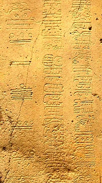
The Maya system is based on twenty units. The numbering system uses three symbols: a shell for zero, a dot for one unit, and a line for five units. Since they used a vigesimal positioning system, numbers grow multiplied by twenties. The numbers are written vertically or horizontally.

The Maya Stela is read top to bottom. Glyphs and numbers denominate the day and month of the calendar as well as the period: Baktun, Katun, Tun, Uinal, and Kin. The Long Count calendar is built of three coordinated sub-calendars. The first is an astronomical calendar, 365.2420 days long, and was used to predict the solstices. The civil calendar Haab, 365 days long, is eighteen twenty day long months and a five day long month, Uayeb. The third calendar is the Tzolkin, 260 days long. This calendar was used by priests to set days for agricultural labor and religious ceremonies. The Tzolkin was also used as a secondary calendar system called the Sacred Round that combined the 13 day numbers cycle and the 20 day names cycle. The Maya designated an overlapping day in the Haab and Tzolkin calendars that created a joint cycle called the Calendar Round. The basic unit of the Maya year is the Kin, or day. The twenty day cycle of thirteen day numbers is the Uinal. The Maya year is split into nineteen parts, or months, each with a name and a glyph. Numbers are designated glyphs that correspond to the time period.

Detail showing three columns of glyphs from 2nd century CE La Mojarra Stela 1.
The left column gives a Long Count date of 8.5.16.9.7, or 156 CE.
The two right columns are glyphs from the Epi-Olmec script.


Profile-photo
About the Author


I'm Melanie, the founder of BermudaQuest and an archaeology undergraduate at the University of New Mexico. I love writing about ancient and modern cultures. My goal is to make information about our origins available to everyone [in simple English!]

Painted Caves: Pech Merle

on 09 February 2012

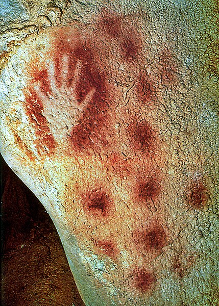
The Pech Merle cave is close to the Cabrerets village in France. Pech comes from the French word puèg that means hill. As for Merle, the origin is unknown. The cave has no signs of prehistoric use in the upper network. The lower network galleries were discovered in 1922 by André David and Henri Dutertre. The cave paintings and engravings were examined by Father Amédée Lemozi. The cave was opened to the public in 1926 as a “historic monument” and is property of Cabrerets. It is over two kilometers in length, and a third is open to visitors. The seven large halls display subterranean sceneries. Within ten kilometers, there another dozen painted caves sealed off from the public. 

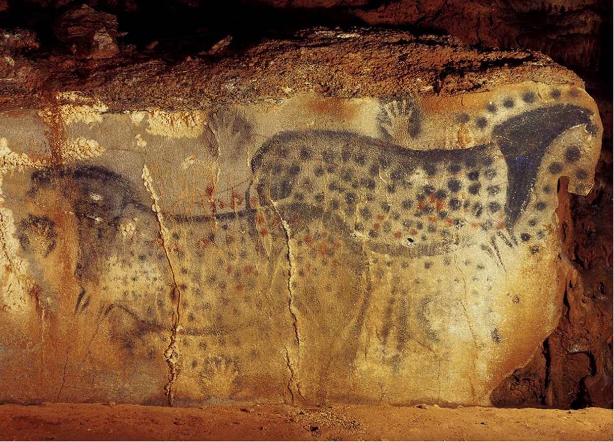
Painting of horses and hands, SlideShare
In 1992, Michel Lorblanchet and Mrs. Hèléne Valladas took samples from the Cougnac cave. Valladas returned with her team and radiocarbon dated the megaloceros panel to 23,000 – 25,000 years old and the dots to 14,000 years old. In 1995, Michel Lorblanchet and his team of specialists took samples from the black contour of the “dotted horses” painting in Pech Merle. The samples were a mixture of manganese and barium oxide. Valladas later radiocarbon dated one of the twenty samples – the other nineteen had too little charcoal – to around 25,000 years old. 

Cave painting of human hands, Wikipedia Commons
In 1998, bones were discovered in the Ossuary hall of Pech Merle. The hall is decorated with paintings and finger drawings. The floor of clay was crammed with animal bones and a path was created for visitors in the low dome room. Later, Jean Claude Faurie took bone samples and so far 118 have been marked, studied and drawn. The bones are from bears, cervidae, reindeers, horses, hyenas, lions, aurochs, and bison. Of these, a bone is engraved by man-made notches and others have been sawed. In 1998, an additional cave was found in the area, Pestillac.


Profile-photo
About the Author


I'm Melanie, the founder of BermudaQuest and an archaeology undergraduate at the University of New Mexico. I love writing about ancient and modern cultures. My goal is to make information about our origins available to everyone [in simple English!]

Africa's Colonial Borders: In the Process of Costly Change

on 27 January 2012

Guest Blog by Richard Chowning 

While some people are still under the erroneous impression that Africa is a country, the vast majority are unaware that the borders that delineate the fifty-four current African countries in no way represents the ancient ethnic kingdoms and tribal territories. In fact, the colonialists drew up the boundaries to suit their own ends and have left the peoples of Africa some real problems. 

Look at a map of Africa. Those lines that divide the countries are a mixture of rivers and rulers. Without a doubt, the rivers are natural demarcations that have separated African peoples since ancient times. But the many straight lines are the work of visitors to the continent, namely the colonial powers of Great Britain, France, and Portugal. 


The Europeans partitioned Africa into realms that they believed they could easily influence. They setup government sponsored trading companies to acquire the minerals and produce within the nations and brought in troops to protect their investments. Those unnatural borders were drawn up in in European capitals during the early years of their settlements in Africa. These colonialists had scant knowledge or appreciation for overall geographic and ethnic makeup of the continent. Without a doubt the impact of the colonizers on Africa was at best mixed. There is ample research in African history[1] that the major impact Europeans had on Africa was not the terrible exploitation of Africans, but the drawing of unnatural and improper borders that have remained long after they achieved independence.

A recent study by Michalopoulos and Papaioannou, “The Long-Run Effects of the Scramble for Africa” has added some hard facts to what others have theorized. In analyzing the location, duration, and total casualties data from all civil wars in Africa in the post-independence period (1970 − 2005), they concluded, “Our most conservative estimates suggest that civil conflict intensity, as reflected in casualties and duration, is higher by approximately by 25% in areas where partitioned ethnicities reside as compared to the homelands of ethnic groups that have not been separated by the national borders.” They also found that ethnic groups that were not partitioned, but were adjacent to partitioned ethnic groups experienced higher than normal incidents of unrest.

The colonial borders have remained in place since independence – more than 60 years in most cases. With the birth of the nation of Eritrea, a few years back, and the creation of South Sudan this past year, Africa may very well be witnessing the beginning of the redrawing of national boundaries. They new borders will more properly reflect the natural, ethnic make-up of nations.
Terrorist activities in Africa are at their root struggles of minority ethnic groups to gain control of their homelands. The al-Qaeda linked, al-Shabaab terrorist in Somalia have plunged that country into a civil war that has left the country without an effective and viable government and will most likely result in that nation being divided into three countries within the next two years. Boko Haram terrorists in Nigeria are carrying out bloody attacks because they feel that the ethnic groups of the north, who are predominantly Muslim are being marginalized by the more Christian ethnic groups of the south. Many analysts believe that the current attacks by Boko Haram will plunge the country into civil war and ultimately will divide Nigeria, Africa's most populous nation, into two countries. 

The impoverished African continent will redraw many of its borders, but not without the cost of much bloodshed. 


Richard Chowning is editor of Terrorism in Africa and owns and writes for more than a half dozen Africa oriented websites.


References
[1] Asiwaju, A. (1985): “The Conceptual Framework,” in Partitioned Africans, pp. 1—18. St.
Martin Press, New York. And, Wesseling, H. L. (1996): Divide and Rule: The Partition of Africa, 1880-1914. Praeger Publishers, Westport, Conn.

Share This

Never miss an article, subscribe here!

Credits & Policies

Banner created by Melanie Magdalena.

Images courtesy of: Ricardo Liberato (Pyramids of Giza), Aurbina (Moai), Maria Reiche (Nazca), Zunkir (Gobekli Tepe), Bjorn Christian Torrissen (Chichen Itza), Gareth Wiscombe (Stonehenge).

Images were released to the public and/or licensed under Creative Commons.

Editor's Note

Welcome to BermudaQuest, a free online journal primarily about Archaeology, Ancient History, and stories about different cultures from around the world.

Founded by Melanie E Magdalena, BermudaQuest and Origins (our magazine) have over a million readers! We would love to include your insight, experience, photos, and thoughts about your culture, heritage, and travels. Make sure you check out Origins, with over 4 million readers!