Showing posts with label Culture. Show all posts

Symbols & Their Mysteries

on 15 October 2012

Petroglyph comes from the Greek words “petro” meaning stone and "glyphein" meaning to carve. They are created by removing rock surface either by picking or carving. Petroglyphs can be found all over the world and some can de as old as 40,000 such as in Australia. They were made until the 20th Century by by the Southwestern cultures. These glyphs depict many things: from warriors to animals and the Death god.

Group of Warriors, Rinconda Canyon
Home to over 24,000 petroglyphs, this 17-mile wide monument (established in June 1990) is located in western side of Albuquerque, New Mexico. The monument is managed by the National Park Service and cooperation with the City of Albuquerque. The western boundary features a chain of dormant volcanoes; Butte volcano in the northwest corner and to its south the Bond, Vulcan, Black and JA volcanoes.

Jose-Pierre Estrada on top of JA Volcano, Petroglyph National Monument
Vulcan Volcano, Petroglyph National Monument
Petroglyph National Monument also protects a variety of archeological sites and an estimated 24,000 petroglyphs carved by Ancestral Pueblo peoples and early Spanish settlers. Most of the glyphs are recognizable as animals and people, but the more complex ones are obscure and their meaning is only understood by the artist that carved them centuries ago. 

Spirals and Hands, Rinconada Canyon
Two thousand or more years ago, hunter-gatherers began etching their circles, "squiggly" lines, and other curvilinear abstract symbols. They are among the oldest petroglyphs in the area and are dated as far back to the Archaic period. As time goes by, the rock art begins to be more geometric and more iconic to depict beings such as shamans and have more symbolic meaning. 

More recent petroglyphs reflect the Rio Grande Style starting around 1300 CE, when Puebloan ancestors began emigrating from the Four Corners Region. The style includes human figures such as flute players and dancers, to masked figures and animals such as serpents, birds, big horn sheep, and mountain lions. Proof of their relations is some of the petroglyphs designs match those appearing on pottery such as those associated with Pueblo 1 culture.

Spanish colonists had an impact on the native soceities when they arrived in the late 17th century. spanish authorities repressed Pueblo religious life and rituals. Occasionaly Spanish markings, the Christian cross, were etched along the natives glyphs as they believed to have evil effects or relation to pagan symbols.

Cross Petroglyph, Boca Negra Trail

Human Figure & Spiral Sun, Boca Negra Trail


Snake & Family of Armadillos or Big Horn Sheep (?), Rinconada Canyon

Mountain Lion, Rinconada Canyon

Facing Birds, Drum (?) & Star, Boca Negra Trail

Spiral, possibly a Maze, Rinconada Canyon

God of Death carved on rock edge, Rinconada Canyon

Double Spiral & Animals, Rinconada Canyon

The crew attempting to decipher petroglyphs...

Mosaic of Petroglyphs, Rinconada Canyon

Turtle or Person (?), Rinconada Canyon

Shield, Rinconada Canyon

Shield with Stars or Planetarium, Boca Negra Trail

Mountain Lion, Boca Negra Trail

Unknown Symbol, Boca Negra Trail
This October we plan on visiting one final petroglyph trail and we will add more photos and a video... Stay tuned!


For Further Viewing


Please visit our Google Plus album to view all of our photos of Petroglyph National Monument taken during September 2012 :: View album>>
Creative Commons License
Petroglyph National Monument photos by Melanie E Magdalena are licensed under a Creative Commons Attribution-NonCommercial-ShareAlike 3.0 Unported LicensePermissions beyond the scope of this license may be available. Contact editor@bermudaquest.com for commercial permission.

Discovering the Past in Modern Vancouver

on 24 September 2012

If you find yourself in Vancouver with some free time to kill, a sense of adventure to satisfy, and an interest and appreciation of history to fulfill, then you’re in luck, as Vancouver offers numerous historical sites and landmarks that will without a doubt quench your thirst for history and adventure!

Gastown Steam Clock
[Leonard G./Wikipedia]

Proud Canadian Tradition

To start the sightseeing off, you can pass by Gastown, in downtown Vancouver. Going through Gastown will give you a very good idea of the rich and diverse roots of the rest of the city. Gastown takes its name from Jack “Gassy” Deighton, a sailor turned bar owner who established the city’s first saloon. The town quickly developed and flourished, as numerous businesses and establishments opened, making Gastown a melting pot of diversity, trade, and commerce. By 1886, Gastown had officially become part of Vancouver. Unfortunately, Gastown was not spared from the Great Vancouver Fire, which destroyed most of its buildings and history. However, in a testament to the spirit of Gastown’s citizens, the town was rebuilt and — driven by an interest to preserve the historical and architectural merit of the town — was recognized as one of Canada’s National Historic Sites. Today, Gastown is a popular tourist site that holds numerous antique and culturally significant landmarks, such as the Gastown Steam Clock, which is a proud, locally maintained site that also has become a hub of modern technologies and a lively nightlife.

The Great Outdoors

National Geographic Tree
[Public Domain]
Looking for a more outdoorsy, nature-intensive romp in Van-couver? Well, Stanley Park might just be the perfect place for you. Named after the former Governor General of Canada, Lord Stanley of Preston, and opened in 1888, Stanley Park can provide you with a physically as well as culturally stimulating visit. Stanley Park contains an impressive collection of gigantic, colossal trees such as the National Geographic Tree, an enormous western red cedar that was featured on the cover of National Geographic, and the Hollow Tree, popular because of its hollowed out insides that made it a great tourist stop. There are also various lakes, ponds, and lagoons that offer visitors great scenic views. Scattered throughout Stanley Park are monuments, statues, and landmarks that honour many Canadian heroes, former leaders, poets, and athletes. Totem poles are also a common site in Stanley Park, underscoring its past as home to the many indigenous tribes of Vancouver.

A Taste of Diversity

The great city of Vancouver is also home to a large and thriving Chinatown (in fact, one of the biggest and oldest Chinatowns that can be found in the whole of North America). In close proximity to Gastown, Vancouver’s Chinatown presents you with a unique opportunity to have an authentic and interesting Chinese experience right in the middle of Canada. With a community spanning generations of Chinese-Canadian immigrants, you can be sure that the shops, restaurants, markets, and other establishments there are 100 per cent authentic and traditional. Vancouver’s Chinatown is truly one of the ideal examples of marriage between a foreign culture and the Canadian lifestyle.

Dr. Sun Yat Sen Classical Garden
Chinatown, Vancouver
[Public Domain]

Explore Vancouver!

Vancouver holds the promise of many more gratifying and stimulating encounters, and these are just a sample of the many historical and cultural sites in Vancouver that you can enjoy. For a more rewarding experience, just go ahead and discover for yourself what the rest of Vancouver has to offer!

About the Author

Jay Banks of Vancouver Homes has been a Realtor from Vancouver BC for more than 16 years.

Flaming Zozobra

on 10 September 2012


The most anticipated event in the southwest is the annual Fiestas de Santa Fe, held the first weekend in September. For the past 300 years Santa Fe hosts a 3 day festival that began in 1712 to celebrate an expedition by Don Diego de Vargas, who re-conquered the territory of New Mexico.

Order obliging the citizens of Santa Fe to celebrate henceforth the 14th day of Sept. of each year as the anniversary of the re-conquest of the said Villa by Diego de Vargas.” Spanish Archives of New Mexico; Archive 179, Sept. 16, 1712. 

The centerpiece of the celebration is the burning of 1600 pound, 50-foot giant monumental effigy, the Zozobra, created in 1924 by local Santa Fe artist William Howard Shuster. Inspired by the effigy, Judas, from Holy Week in Mexico, Shuster set out to create the Zozobra now holding a Guiness World Record. Judas was filled with firecrackers and paraded by donkey around town and ultimately set on fire. Zozobra, the gloomy one, is Shuster’s growling version, “[the] mischievous and hideous boogey man.”

Each year the Kiwanis Club of Santa Fe stages the ceremonial burning of Zozobra. The ceremony opens with a speech persecuting Zozobra:

The time has come to consider the fate of Old Man Gloom.
Zozobra for being a mischievous and hideous 50-foot boogey man… Guilty!
For scaring our innocent children with your miserable growling… Guilty!
Zozobra big dog howling at the moon filling our dreams… Guilty!
Zozobra for upsetting our peaceful way of life with your dark gloominess… Guilty!
Zozobra for bringing sadness anxiety and gloom into our lives… You are guilty!
The Zozobra, Old Man Gloom, will be dispatched by the ceremony of fire. 
All that bear witness will be free of sadness and suffering. 
Let the darkness bring us light! 

Immediately after the fiery sentence, elaborate tribal-styled dances and fire wielding performances begin. The effigy begins to growl as fireworks and nearby flames light up the darkness. And then... he burns.


The burning of Zozobra is a tradition that everyone should experience at one point in their lives. Whether you believe that it will cleanse and free you from your troubles or you just want to feel the excitement… you'll be sure to find yourself chanting “BURN HIM!!”

The Lost Culture of the Mississippian Floodplain

on 06 August 2012

Before Columbus, one of the largest and sophisticated cities of America, rivaling even some of the largest cities in Europe, thrived on the floodplain of the Mississippi. This powerful culture influenced surrounding ones from the Great Lakes to the Gulf of Mexico. And then, suddenly, they all disappeared.

Entering the Cahokia Mounds State Historic Site, viewing Monk's Mound
[Northfielder/Flickr]

During the Mississippian period (800-1400 CE), Cahokia, located in southwest Illinois (just outside of St. Louis), had around 120 mounds which covered nearly 1,600 hectares. This is the largest pre-Columbian archaeological site in North America north of central Mexico, as well as the earliest. According to UNESCO, Cahokia is an exceptional example of pre-urban structuring. Also, "it is the pre-eminent example of a cultural, religious, and economic center of the prehistoric Mississippian cultural tradition." The size and layout of this pre-urban society is evidence of the powerful political and economic system that was in place, which can be held responsible for organization of labor, trade, and agriculture.

Cahokia was larger than London in 1250 CE. The Mississippians built a variety of structures: from practical homes to monumental public works that still remain. The agricultural society may have had a population of 10,000 - 20,000 at its peak (1050-1150 CE). And though this culture left us no writing, we have mounds.


Meet the Mounds


What They're Made Of


The Cahokia used earth and wood for their architecture. Examples of this can be seen in their mounds and in their homes. Wooden palisades encompassed many zones which were possibly defensive enclosures; this is seen at Monk's Mound and the entire central section of the site. Red ochre was found in postholes which may suggest that ochre was used as paint.

Monk's Mound & The American Woodhenge


Monk's Mound is the largest prehistoric earthwork in the Americas. It covers over 5 hectares and is 30 meters tall. This mound is where the leader of the community resided. In the early 1960s, Dr. Warren Wittry discovered a series of large oval-shaped pits, which later revealed fragments of red cedar (considered a sacred wood) that served as posts. Dr. Wittry named this Woodhenge. The posts mark the sunrises during the equinoxes with the front of Monk's Mound.

Monk's Mound
[reallyboring/Flickr]
Woodhenge
[Nathaniel Paluga (Drpaluga)/Wikimedia Commons CC-BY-SA 3.0]


Fox Mound & Round Top


The mounds known as Fox Mound and Round Top (also known as Moorehead's Mound) seem to have been joined by a platform (though, it's equally possible the mounds blended together over time). Fox Mound, at 14 meters tall, is a flat-top platform mound that has never been excavated. It's companion, Round Top, is a true conical mound about 13.4 meters tall which is also untouched. These two mounds retain much of their original forms today.

Fox Mound
[Lance and Erin/Flickr]
Round Top
[Lance and Erin/Flickr]
Fox Mound (left) and Round Top (right) as seen from the top of Monk's Mound
[jmehre/Flickr]

The Site Outskirts


Around the edges of the site lie the remains of resential quarters, areas for specialized activity, and public ceremonial areas. The living areas had small gardens, but the agricultural lands are found beyond the city-limits as well as small satelitte villages.

A diorama showing a Mississippian potter [LEFT] and woman grinding maize with a stone mortar [RIGHT],
from the Cahokia site museum.
[Herb Rose/Wikimedia Commons CC-BY-SA 3.0]


The Mystery of Cahokia

Where did the people of Cahokia go? Did other tribes absorb them? Did they create new tribes? Many questions remain unanswered about the Cahokians. The decline of their civilization may have begun around 1200 CE - we know that by the 1400s they were gone. Perhaps they depeleted their resources and were forced to move...war may have struck...maybe it was a disease. Political and economic power may have declined. We know they were a thriving community that made significant advances in astronomy, agriculture, and economics which probably spurred development in other regions of America.


Cahokia Today

Despite the four lane road that runs cuts through the site, Cahokia Mounds is one of eight cultural World Heritage sites in the United States. Ten miles away, only one mound remains. About 890 of the 1600 hectare site is protected. Of the 120 mounds, 109 have been recorded and 68 of those lie within the protective range of Cahokia Mounds State Historic Site. The rest lies under urbanization. Few know of the existence of Cahokia outside of St. Louis, IL. We may only see piles of dirt, but these piles of dirt tell one of the oldest stories of our American heritage.


For Further Reading


Cahokia Mounds State Historic Site :: www.cahokiamounds.org
Cahokia, America's Forgotten City (National Geographic) :: ngm.nationalgeographic.com
UNESCO Cahokia Mounds :: whc.unesco.org

Evolution: please don't stop the music

on 28 June 2012

By Alan Harvey, University of Western Australia

Christine Westerback/Creative Commons
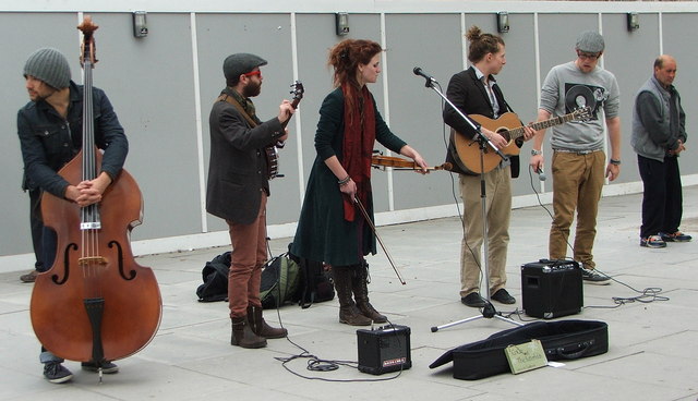
All human cultures and social groups that we know of respond to music and dance. The type of music may vary but the underlying, fundamental principles of making music are the same.

Our recognition of, and emotional responses to, pleasant and unpleasant music seems to be universal, expressed even in very young infants and seemingly independent of our cultural upbringing.

So what exactly is music for? Why is it a universal that can profoundly affect people, why is it such an essential part of our lives?

Music is a form of communication which is different from language. In humans, music stimulates emotions and elicits autonomic and physiological responses. It entrains neural activity and is inextricably linked to movement and dance.

Music facilitates interactions within groups and can create common arousal states. It helps to provide cohesion and organisation to our social architecture.

Throughout recorded history, leaders – whether of nations, political parties or religious denominations – have understood the power of music to influence populations.

In recent times, researchers have shown that music structures time and provides mnemonic frameworks that aid learning and memory, help organise knowledge. Many of us can remember the lyrics of songs for example, but may not remember much, if any prose.

Attaching words to music somehow makes the words easier to memorise. Yet despite all of this, the impact of music remains mysterious: it does not seem to do anything, it does not transmit data and information in the same way as language/speech.

For many, the evolution of language in Homo sapiens is a unique event that is linked to the evolution of the cognitively modern mind. What then is the relationship between music and language, and to what extent are they dependent or independent of each other?

Human Brain [MRI Scan]
taod/Creative Commons
Our brains are known to be wired to process both forms of communication, but from an evolutionary point of view did music come before language, or vice versa, or was there a common precursor that somehow separated into two systems when Homo sapiens evolved, with both types of communication retained?

Was music an important element that contributed to the early well-being of our species? What, if any, advantages did music give to Homo sapiens from an evolutionary perspective as our founders migrated out of east Africa to colonise the planet?

Why does music continue to exist alongside language and remain important to all human cultures, thousands of generations after the founders of our species evolved?

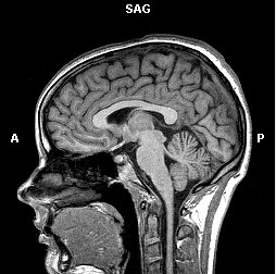
Modern neuroscience research, especially using new imaging techniques such as positron emission tomography (PET) and functional Magnetic Resonance Imaging (fMRI) confirms that the processing of music has a consistent structural foundation in the human brain.

It has been known for some time that, in right-handed individuals, language is mostly processed in the left cerebral hemisphere while many aspects of music involve right hemisphere activity.

But new imaging data have revealed even more complex circuitries involved in music and language processing. Numerous regions of the brain are integrated into networks that subserve music or language processing and analysis, but the neuroimaging data also show that separation of these processing streams is by no means complete.

For example, there is overlap in brain areas that process the emotional (prosodic) aspects of music and speech, and studies have shown that musical training results in a shift towards processing in the left cerebral hemisphere.

As research continues, more is learned about how music-related circuits differ from, or overlap with, other pathways involved in cognitive and emotional processing. For example, brain areas associated with positive responses to music overlap with networks associated with reward behaviours, subjective experiences and acts of social cooperation.

In close association with the evolution of the modern mind, I believe music was of critical importance to our early ancestors; increased fitness and reproductive advantage of a group is gained not only by an individual’s success but also if cooperative behaviours benefit other members of the group, and importantly for our ancestors these benefits extended to others who were not necessarily genetically related.

For most people, music therapy remains a branch of “alternative” medicine, something outside the mainstream. But recent research suggests that it is time that this attitude was changed.

For example, training in music has measurable effects on brain plasticity and can influence learning ability during development. Music also seems to have mnemonic powers, activating circuits in the brain that are linked to aspects of memory processing.

There are also structural changes in developing brains associated with early musical training, and exposure to music seems to have beneficial effects on children suffering from developmental disorders such as autism and Williams syndrome.

In adults, many studies have shown that music used with physical therapy improves motor control and coordination, with benefits for rehabilitation after injury or in degenerative conditions such as Parkinson’s disease.

Music therapy may also improve memory recall and social awareness in Alzheimer’s patients and recent studies on stroke patients have shown that controlled exposure to music improves cognitive function, increases motivation and awareness, and enhances positive mood states.

Taken together, the evidence suggests that music remains just as essential to Homo sapiens now as it was 70,000-80,000 years ago. It continues to be important for development of our children, for our health and for our overall sense of mental well-being.

Above all, music is perhaps the primary medium which enables individual members of the species Homo sapiens to forget their mortal vulnerability and come together as a collective group to share and enjoy common physiological and emotional experiences.

Profile-photo

About the Author

Alan Harvey was educated at the University of Cambridge and Australian National University. He is currently Professor and Deputy Head of the School of Anatomy and Human Biology. He has the long-term ambition of bringing his neuroscience and musical interests together, intending to write a book about the role of music in human evolution and modern-day society.
Alan Harvey receives funding from the NHMRC, ARC and WA Neurotrauma Research Program.
The Conversation
This article was originally published at The Conversation. Read the original article.

Oasisamerican Cultures: The Fremont

on 22 March 2012

The Fremont are one of three minor traditions/cultures that developed in the prehistoric southwest, mainly in the area of what is now Utah. The culture is named after the Fremont River in the state of Utah where the first distinctive Fremont sites were discovered. At first, the Fremont were considered to be an inferior branch of the Anasazi culture, but now its considered to be a distinct and unique culture; a less socially organized culture but just as adaptable. There are still current debates regarding whether the Fremont were Anasazi people who migrated into Utah or if the culture was created by local Indians under Anasazi influence.

Fremont Petroglyphs at Buckhorn
Kerkphil via Wikimedia Commons

Origins


Archaeologists believe that as early as 400 CE, existing groups of hunter-gatherers on the Colorado Plateau and eastern Great Basin developed into the Fremont. Soon after, corn and other cultivated plants were being grown in central Utah, although these early Fremont farmers did not build settled villages, but remained nomadic throughout the year. Farming and pottery then gradually began to spread from this region to the rest of the Fremont area, which includes most of present day Utah and extends well into central Nevada and other neighboring states. Due to favorable climatic conditions and a keen knowledge of the area, roughly between 700 and 1250 CE was the height of Fremont culture, as well as other southwestern prehistoric cultures. Settled village life had developed in the heart of the Fremont region, with a number of farming villages consisting of semi-subterranean timber and mud pit houses and above-ground storage houses. Fremont farming techniques were as sophisticated as those of other contemporary farming societies, such as irrigation techniques. This lifestyle continued unchanged for the Fremont for about 500 years, but eventually climate changes would irritate the land.

The Anasazi inhabited the south-central portion of the Colorado Plateau, particularly the Four Corners region, while the Fremont culture did not extend south of the Colorado River. So archaeologists ask the question: How much interaction existed between these people? Sites in Grand Staircase-Escalante National Monument and the Henry Mountains near the current Arizona/Utah border indicate cultural interactions between the two groups, including trade and possibly intermarriage. It is interesting that Anasazi archaeological features diminish and Fremont features increase as one moves north along the Green River.

What made them different?


Moki Hut (Granary) in a canyon crevice
near the Fremont River.
Bob Palin via Wikimedia Commons (CC)
Archaeologists studying the Fremont have found only four distinct artifact categories which readily identify this society from others of its time, since pithouse design, horticulture, and projectile points were similar across all prehistoric southwestern cultures. The four "classic" Fremont artifacts are:

1) a unique one-rod-and-bundle basketry style,
2) moccasins constructed with the dew claws a deer or mountain sheep forming the heel,
3) a distinctive art style used in pictographs, petro glyphs, and clay figures depicting trapezoidal human figures decorated in necklaces and blunt hairstyles, and
4) coiled gray pottery. 
Fremont archaeological sites, ranging from villages to small camp-sites, have been identified in practically every ecosystem of the Great Basin/Colorado Plateau region. Artifacts such as snare traps, rabbit nets, fur clothing, leather pouches, and bows and arrows proves that the Fremont developed adapted in order to reside in their imposing environment.


Pilling Figurines
Brian Lee via Wikimedia Commons (CC)

Adaptation and Disappearance


Even though they showed adaptation to the environment, between 1200 and 1500 CE, the Fremont culture began to vanish. Their exact disappearance is unknown but there are several posibilies that together contributed to bring down the Fremont. Climate changes might have made farming more difficult due to decreased precipitation. Competition for the limited resources with migrating Numic-speaking ancestors of the Ute or Shoshoni people might have caused them to die off or they may have been absorbed into a new culture. Whatever the reason might be, the Fremont showed impressive resourceful knowledge of the land they inhabited and thrived for over fifteen hundred years.

Profile-photo
About the Author


I'm Jose Pierre and I like learning about all aspects of culture, both ancient and modern. I enjoy learning how they communicated, expressed themselves, and their technology.

Oasisamerican Cultures: The Hohokam

on 21 March 2012

The Hohokam culture was located in the desert region of southern Arizona. The Hohokam are thought to have originally migrated/traveled north out of Mexico around 300 BCE, bringing Mexican traits with them. They were creative artisans who are famous for their work with shells obtained from the Gulf of California and creative coiled pottery painted with red designs. It is probable they traded with peoples of northern Mexico because there was a great deal of Mesoamerican influence found, such as ball courts and decorative feathers.

The Hohokam became the most skillful irrigation farmers the southwest ever knew. They developed an elaborated irrigation networks using stone instruments and labor. This gave them the name of “canal builders”, until modern development obliterated their canal systems.

Artifacts and Architecture


Hohokam Etched Shells
National Parks Service via Wikimedia
Archaeologists use artifacts as markers to help identify stages in chronology of a culture or tradition. Pottery that is similarly shaped and decorated is considered to date from the same period. Details and decorations that indicate periods within the Hohokam tradition include coiled pottery made from a tan-colored clay from the Arizona hills decorated with designs painted in darker orange-red clay. Hohokam pottery is commonly referred to as Hohokam red-on-buff pottery.

Ceramic painted vessel (600-900 CE)
Wikipedia loves art via Wikimedia


Archaeological artifacts found in Hohokam sites vary from traditional stone tools to jewelry, most common are stone axe heads with deep grooves for attaching wooden handles. Long flat stone slabs or pallets have also been found and are believed to have been used to grind pigments or colored stones. Other artifacts include distinct arrow points with jagged edges and elaborate shell ornaments such as pendants and bracelets made of seashells from the Gulf of California. One of the more important artifacts found are small copper bells. The bells are evidence that the Hohokam did indeed trade with people of Mexico. Same as pottery, artifacts found in Hohokam sites or other deposits can serve as markers to date accompanying objects or other evidence.

Little is known about the appearance of Hohokam people. Archaeologists rarely find skeletal remains in Hohokam sites because they cremated their dead. They would then place the ashes into their distinctive red-on-buff pottery jars.

Structures found on Hohokam sites consisted of clusters of shallow pithouses similar to those of the anasazi culture. Impressive ball courts have also been uncovered, but they were not like ball courts found in Mexico, the Hohokam courts were large oval shaped basins.

Where did the Hohokam go?


Their fate is unclear but they seemed to have disappeared around the 15th century, the time when the Spanish first came upon the Hohokam descendants (by then the Pápagos lived in the area). Perhaps crop failures or raids from prehistoric Apache tribes led to their collapse. The Hohokam could have retreated and scattered into small villages, most likely their descendants remain in the desert today as new tribes and cultures.

Montezuma's Castle: built by the Sinagua tribe around 1400 CE [not related to Moctezuma]
Phillip Capper via Wikimedia


Profile-photo
About the Author


I'm Jose Pierre and I like learning about all aspects of culture, both ancient and modern. I enjoy learning how they communicated, expressed themselves, and their technology.

Oasisamerican Cultures: The Anasazi

on 19 March 2012

The Anasazi culture is one of three major traditions/cultures identified in the southwestern area of the United States, mainly the "Four Corners" area also identified as where Arizona, New Mexico, Utah, and Colorado meet. The Anasazi are not a tribe nor did anyone call themselves by that name. Archaeologists apply this name to the people who farmed the “Four Corners” before 1300 CE. A culture is identified through its artifacts, architecture, crafts, and symbols used during a certain time period.

Chaco Culture: clay bowl and turquoise pendant
National Parks Service via Wikimedia
Anasazi is Navajo for “the ancient ones”. Before the start of the first pueblo period, the Anasazi were considered “basket makers” because of predominant artifacts found in sites.

A pueblo period is defined as the shift from a time when people made light baskets and nomadic movements, to heavier pottery used to keep food from spoiling and people who settled and did not move frequently.

Beginning around 700 CE (First Pueblo Period), they were considered Pueblo People because they began producing pottery. Much of the earlier pottery had simple designs and decorations such as lines, dots, zigzags, but then overtime (and maybe some influence from the Mogollon and Hohokam) designs become denser and more precise with bold geometric patterns in black-on-white and representations of birds, lizards, or humans.

Why is pottery important
to archaeologists?
Pottery contains clues about the people who made it. Styles and designs change through time, and vary across regions. Pottery can be sorted or "typed" into categories based on grouped traits such as color, texture, decoration and vessel shape. Archaeologists often name a ceramic type after the place where the pottery of that style was first identified--for example, Mancos Black-on-Gray (from Mancos, Colorado) or Tin Cup Polychrome (from Tin Cup Mesa, Utah). Archaeologists then follow the principle that most pottery made in one place and time tends to be fairly uniform in decoration given that ceramic fragments ("sherds") can somewhat show when a household or village was occupied. Since certain designs are unique to specific geographic areas and periods, studying and classifying designs can help reconstruct social interactions, communication, and trade relationships between regions. It would be valuable to know if certain designs "belonged" to a family, clan, or village; or how free a potter was to invent or borrow designs.

Pit Houses

Early Anasazi architecture was made up of family unit pit houses which were shallow and roofed over with wood and mud. Later pit houses were dug deeper with only the entrance visible on the surface. Above ground storage rooms were built strictly for storage of food, but eventually they became living/sleeping/working rooms. Pit houses then transformed into what archaeologists refer to as Kivas, a square underground room for religious ritual. Inside a kiva, a deflector wall is in front of the entrance to regulate the entering draft, and most of the time a hearth pit is at the center. Between the regulator wall and the hearth pit is a small hole in the floor called a sipapu, which symbolizes the “hole through which the Anasazi believed humanity originally emerged from the underworld.” Another type of kiva is a “great kiva”, exactly the same as a regular kiva only larger to host community events and rituals.

Kivas at Chaco Canyon, New Mexico
National Parks Service via Wikimedia

Cave Dwellings

Between 1200 and 1300 CE, many large and small pueblos were built into shallow caves known today as "cliff dwellings.” Cave dwellings offer several environmental advantages such as shelter for the buildings from rain and snow, usually have a good solar orientation (shade in the summer, sun in the winter), a spring is often found at the back of these caves, and do not occupy scarce agricultural land. An example of cave dwellings are the Mesa Verde villages. At first they were compact apartment complexes located on top of the mesa. But by 1150 almost all Mesa Verde villages had moved to more defensible shelters in the sides of the mesa's cliffs. Large natural rock overhangs provided enough space to construct towns such as Cliff Palace, which contains more than 200 rooms and 23 kivas. Access to the cliff dwellings was difficult and easily protected. The large proportion of kivas to rooms at Cliff Palace indicates that the town was probably a ceremonial center for many of the other smaller villages of Mesa Verde.

Cliff Palace at Mesa Verde
Lorax via Wikimedia (CC)

Chaco Canyon

Anasazi sites are found throughout Chaco Canyon National Monument, New Mexico. Chaco towns were connected to each other by a web of roads and were thriving places from 950 to 1300 CE. The roads connected to sites such as Aztec Ruins near Aztec, New Mexico, and the Salmon site near Bloomfield, New Mexico. More than 125 sites and 250 miles of have been found and mapped in this prehistoric network of roads. The most impressive towns in Chaco Canyon were large, D-shaped communities such as Pueblo Bonito, Chetro Ketl, Hungo Pavi, Una Vida, Pueblo del Arroyo, and Pueblo Alto, many of them containing great kivas for large community ceremonies. Archaeologists believe Chaco Canyon was both a ceremonial center and a center of trade, and both food and luxury goods.

Digital reconstruction of Pueblo Bonito
NASA via Wikimedia

Decline and Separation


Eventually the territories of the Anasazi and all the other Southwest traditions decreased drastically and total population began to decline. Sites on the fringes of the territories were abandoned first, followed by those closer to the traditions' centers. One of the possibilities of the decline is a disastrous drought that was recorded in tree rings from the years 1276-99, and then possibly followed by invasion. Within decades, the constant invasion of possibly the Navajo and Apache were joined by the Spaniards, and the Indian villages of the Southwest came under both native and foreign domination by the 17th century. Even after several hundred years of occupation and struggle, the descendants of the major Southwest traditions persist today as vigorous communities.


Profile-photo
About the Author


I'm Jose Pierre and I like learning about all aspects of culture, both ancient and modern. I enjoy learning how they communicated, expressed themselves, and their technology.

Firewalking for Spring

on 18 March 2012

Firewalking
Treacle International via Home Page
Spring is upon us with the equinox only days away - it's time to discover balance in our lives. Yesterday was a fascinating day, one I would like to define as an Experimental Anthropology Day.

While researching the Toltec culture, something interesting popped up: The Austin Toltecs group. Today was their Spring Equinox Ceremony. Jose-Pierre and I decided to check it out.

The ceremony began in the evening after voting for our favorite piece from their art exhibit. I voted for the winning painting "Rocks and Water" - a beautiful multicolor abstract piece.

We began by creating a circle, there were about 40 of us present, and after joining hands, called upon the elements with a chant:

"Earth my body, water my blood, air my breath, and fire my spirit."
My future plant © Melanie Magdalena
After opening the circle, each of us found a partner to discuss what we wanted to plant in ourselves this spring and what we wanted to weed out. In my case, I want to increase my sense of security and weedout my impatience with others. Then we joined groups of six and took turns surrendering our bodies to those around us by letting ourselves gently fall into the hands of each group member.

Now that we'd defined how to begin our spring, we took a little pot of soil from the center altar and planted a seed that symbolized our goals. Our intents are like seeds - if we nourish them, they grow!

Once again, we joined hands, this time in two circles around the altar and called upon the elements to close the circle we'd opened.

The night was barely beginning. Next was the firewalk. After watching people overcome their fears of not being able to do something, we went into the night under the skies and chanted again, this time to prove we had overcome our obstacles: Our toes survived!

What I find most interesting about all of this is the fact that many ancient traditions are still alive. People have been walking on fire for thousands of years and we were able to take part in this ceremony that still survives.

I hope you enjoy this pop cultural revival of ancient traditions, you are about to witness The Firedance!


Profile-photo

About the Author

I'm Melanie, the founder of BermudaQuest and an archaeology undergraduate at the University of New Mexico. I love writing about ancient and modern cultures. My goal is to make information about our origins available to everyone [in simple English!]

Share This

Never miss an article, subscribe here!

Credits & Policies

Banner created by Melanie Magdalena.

Images courtesy of: Ricardo Liberato (Pyramids of Giza), Aurbina (Moai), Maria Reiche (Nazca), Zunkir (Gobekli Tepe), Bjorn Christian Torrissen (Chichen Itza), Gareth Wiscombe (Stonehenge).

Images were released to the public and/or licensed under Creative Commons.

Editor's Note

Welcome to BermudaQuest, a free online journal primarily about Archaeology, Ancient History, and stories about different cultures from around the world.

Founded by Melanie E Magdalena, BermudaQuest and Origins (our magazine) have over a million readers! We would love to include your insight, experience, photos, and thoughts about your culture, heritage, and travels. Make sure you check out Origins, with over 4 million readers!