Main attractions within Table Mountain National Park
Table Mountain National Park, which is found in the popular tourist city of Cape Town, South Africa, is a national heritage site and is haven of beautiful natural landscapes and attractions. The Table Mountain National Park offers a number of beautiful hikes and walks for visitors to enjoy and is home to many of Cape Town’s must-visit attractions.
This is where visitors can come and learn about the landscape and environment at the Cape Point visitor centre or take thefunicular or walk to one of the lighthouses overlooking the point where two oceans are said to meet. The reserve surrounding Cape Point is home a variety of birds and lizards as well as some larger wildlife such as zebras, antelope, caracal and ostrich.Spend a couple hours here and picnic at one of the beaches or enjoy a leisurely lunch at the restaurant with spectacular views over False Bay – just remember to keep an eye out for the cheeky baboons!
Boulder’s Beach
Located near Simonstown, Boulder’s Beach is home to a land based breeding colony of cute African penguins. Take a swim on the beach amongst the penguins or simply view these unique birds from one the boardwalks.
Table Mountain
Enjoy a multitude of hikes and walks on the slopes or up to the top of the mountain or if you are not feeling that enthusiastic, enjoy the fabulous views from the cableway. For the more adventurous you can abseil or rock climb the mountain or even stay overnight in one of the little chalets on top of this iconic Cape Town attraction.
Silvermine
Enjoy nature walks on the Constantiaberg Mountain amongst the spectacular fynbos or take a refreshing swim in the beautiful dam or enjoy a picnic on the banks. Silvermine offers something for everyone with waterfalls, dog-walking and mountain bike tracks and even a wheelchair friendly boardwalk.
Signal Hill and Lions Head
The city surrounds these iconic Cape Town landmarks. Thenoon day gun goes off from signal hill and Lions Head is a popular hike for locals particularly when there is a full moon.Take a couple of friends along for a walk and enjoy gorgeous sunset views looking out towards the ocean.
The Spiro Mounds of Oklahoma are only a few miles away from the city Spiro. The mound site consists of 12 mounds, an elite village, and a support village within 150 acres of land. Originally in prehistoric times the mounds area was home mostly to nomads, but as cultures and society began to emerge when ancient people began to become sedentary the Spiro Mounds also transformed into what they are today. By 800 BCE the Spiro Mounds became a permanent settlement that was used until 1450 BCE.
During that time period, which is typically called the Mississippian period the Spiro culture flourished. Archaeological evidence shows that Spiro culture had economic, political, and religious all the way from the Great Lakes to the east coast and the Gulf of Mexico to the Gulf of California. They had an extensive religious center developed as well as a highly developed trade network. The Spiro political system was also able to exert total control over the entire South East. In its height the Spiro people shared an iconographic writing system with over 60 other tribes along with horticulture and extensive ceremonies.
No one is certain as to why the Spiro Mounds were abandoned or why the culture declined, but it was probably caused by a number of environmental, cultural, and political factors. Today the Spiro Mounds are available for the public to explore and at the Spiro Mounds Archaeological Center many artifacts including artistic and utilitarian prehistoric Native American artifacts.
The Cherokee Heritage Center is located in Park Hill, Oklahoma with an Ancient Village and the Trail of Tears being its two major exhibits. It hosts a wide variety of events such as: beading and pottery workshops, educational lectures, and art shows. They also focus on educating the public on Cherokee culture, language, and history. They offer courses in Cherokee Humanities which are accredited courses through Northeastern State University, and other cultural classes including pottery, basket weaving, bead work and making Cherokee moccasins and feather caps. During the Indian Territorial Days they offer the public a way to experience life of what is was like to live in a Cherokee village 300 years ago through activities, games, and living history.
The Ancient Village attraction was opened in 1967 and the location was chosen because it used to be home to the Cherokee Female Seminary. After years of research on Cherokee culture and history construction began. The stations visitors have the option to interact with are stickball, basket making, flintknapping, blowguns, and dugout canoes.
The Trail of Tears exhibit works with the National Park Services in order to permanently house the exhibit which displays the forced removal of Indians from their land onto reservations. It shows the six stages the Indians went through: pre-removal, court battles, prisoners with no crime, a look at the trails other tribes took, removal, and starting over. Each stage is supported by documentation and artifacts in order to display Cherokee culture and history.
One of the major events which will occur at the Cherokee Heritage Center from April 20th to May 27th is the Trail of Tears 42nd Annual Art Show and Sale. The Art Show displays authentic Native American art made by 93 Native American artists from 15 Tribal Nations. The art show will feature 162 art pieces including paintings, sculpture, basketry, jewelry, miniatures, and pottery.
To Learn More Check Out:
http://www.cherokeeheritage.org/
Hunting or climate change? Megafauna extinction debate narrows
By Christopher Johnson, University of Tasmania
What is the oldest debate in Australian science? Probably, the argument over what caused extinction of our Pleistocene megafauna – the diprotodons, giant kangaroos, marsupial tapirs, über-echidnas and other big and bizarre creatures that used to live here.
In 1877 the great English anatomist Sir Richard Owen suggested that these big animals had been driven extinct by “the hostile agency of man”. That is, hunting did it, in a process we now call overkill. Other people responded that climate change must have been the cause, and it was on.
A string of recent studies from a wide range of disciplines – geochronology, palaeoecology, palaeontology, and ecological modelling – have supported Owen’s opinion. But the argument continues. Why?
The main reason is that many Australian archaeologists reject overkill. They have looked for direct evidence that people killed megafauna, and they haven’t found it. No great piles of bones around ancient campsites; no diprotodon skeletons with spears stuck in their ribs; no arsenal of specialised weapons for bringing down large prey. Very few archaeological sites even have remains of people and megafauna in close association.
Some archaeologists conclude that megafauna-hunting just did not happen, or if it happened it was rare and insignificant. Often this conclusion is stated with a ringing confidence that dismisses all non-archaeological evidence for overkill.
But they have not asked a crucial question: if people did hunt megafauna to extinction, how much evidence of killing should we now be able to get from archaeological sites? A new paper by archaeologists Todd Surovell and Brigid Grund suggests the answer to that question is “very little or none”.
Surovell and Grund point out, first, that the period when archaeological evidence of killing of megafauna could have been formed is a small fraction of the total archaeological record of Australia. People arrived here between about 50,000 and 40,000 years ago. This is also the interval during which animals like diprotodon disappeared. A comparison of archaeological and fossil dates suggests humans and megafauna overlapped for only about 4,000 years continent-wide, and modelling suggests that if hunting caused extinction it would have been all over in less than 1,000 years in any place.
This means that no more than 8%, perhaps as little as 2%, of the Australian archaeological record covers the period of human-megafauna interaction. The “smoking gun” evidence of overkill should therefore be rare. Surovell and Grund show that the problem of finding such evidence is even worse than that, for two reasons.
First, when people first arrived their populations were necessarily small. Living sites therefore occurred at low density. As population size grew exponentially, site density increased. So, the very earliest sites must be far rarer than later ones.
But if overkill happened, populations of megafauna would have been going down as humans went up: as the density of sites was rising the proportion of them that could have contained evidence of megafauna kills was falling. Thus, sites with potential to preserve that evidence are actually a tiny proportion, perhaps much less than .01%, of the total archaeological record.
Second, material in archaeological sites degrades with time due to breakdown, weathering and scavenging of bone and removal by erosion. Old sites are eventually buried under sediments. The probability of discovering archaeological sites from the earliest occupation of Australia is intrinsically much lower than for later times, and most of the contents of those sites will have disappeared.
In fact, the very oldest archaeological sites in Australia typically contain only a few stone tools. They can tell us very little about interaction of the first Australians with any animals or plants, let alone reveal a picture of megafauna-killing.
Our fundamental task as scientists is to test hypotheses using evidence. To test the overkill hypothesis, we need a kind of evidence that would differ according to whether the hypothesis is true or false. Obviously, if overkill did not happen, evidence of megafauna-killing should be rare in the archaeological record. But, Surovell and Grund’s analysis makes it clear that if overkill happened, we should still expect evidence of killing to be rare. Therefore, failure to find such evidence does not amount to a test of the overkill hypothesis.
This does not mean that archaeological evidence of killing (or absence of such evidence) is useless in testing the overkill hypothesis. Surovell and Grund show it can be useful, by comparing the archaeological records of Australia, North America and New Zealand. All three places lost their megafaunas when people arrived, but this happened a very long time ago in Australia, and very recently (700 years ago) in New Zealand. North America is intermediate, with human arrival and extinction from 14,000 to 13,000 years ago.
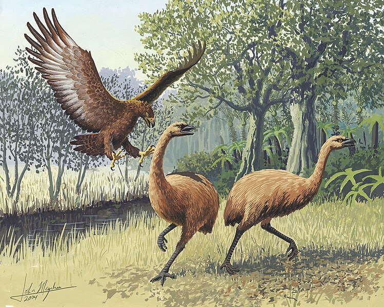
Applying the same logic to all three cases, we predict that if overkill caused megafaunal extinction in each place the archaeological evidence of killing should be abundant in New Zealand, rare in North America, and vanishingly rare in Australia. That is exactly what we find.
There is so much evidence showing New Zealand’s moa were heavily hunted that nobody doubts overkill was the main cause of their extinction. In North America, there are undoubted kill sites for mammoths, mastodons and a few other species, but this evidence is far thinner than in New Zealand. Australian archaeology is yet to reveal any convincing evidence for megafauna-killing.
So, far from disproving overkill, the archaeological evidence from Australia is actually consistent with the overkill hypothesis.
About the Author
Christopher Johnson is an ecologist, interested in pure and applied ecology, environmental history, the biology of extinction, conservation and wildlife management. He is a Professor of Wildlife Conservation and ARC Australian Professorial Fellow at University of Tasmania.
Christopher Johnson receives funding from the Australian Research Council.
Could we have found the first artist’s studio in human history? We may well have.
We all recognise the material signs of wealth. Fast cars, large yachts and sparkling bling all tell us who has more. Crowns, insignia, mayoral gowns are material signs of rank or status.
Archaeologists have long pondered when these public displays of social difference first occurred. Emerging evidence suggests the antiquity of public symbolism is surprisingly great.
Indeed, the symbolism of social difference seems to have been present from the earliest period of our species existence. The rise of Homo sapiens may even have been linked to the use of public symbols.
Recent work in southern Africa, published today in Science, is helping archaeologists clarify the early history of painting and its use in creating symbols.
Discoveries at Blombos Cave
The latest discovery comes from Blombos Cave, a large cavern located on the southern African coast, south-east of Cape Town.
Here a team, led by Christopher Henshilwood of the University of Bergen and Francesco d’Errico from the Université de Bordeaux, has found a 100,000 year old artist’s workshop.
Excavations of the deep sediments piled up in the cave have regularly yielded surprising finds. Archaeologists have previously recovered standardised bone tools, perhaps awls, and delicately-shaped tools of stone projectile points dated to 70,000 years ago.
Henshilwood and his colleagues suggest these tools show ancient artisans were able to plan and create a sophisticated technology.
Even more revealing is the presence of ochre, natural iron-rich rock that can be ground into powder and used as paint. Archaeologists have long suspected pieces of ochre with abraded facets in those early times might indicate paintings of some kind, on rocks, wooden artefacts or even human bodies.
Since 70,000-year-old ochre slabs have geometric engravings on their surface, it is clear early humans were artistic, but until now archaeologists could not be sure they were painters.
The world’s first studio
Now Blombos has yielded new materials that reveal the earliest artist’s workshop.
In a layer 100,000 years old, Henshilwood excavated two containers, which are probably artist’s palettes or mixing-bowls, and associated tools.
Each palette or bowl is a large abalone shell containing a residue of ochre, burnt bone and other materials that had been ground up and combined with some fluid into a vibrant red paste.
One of these containers also contained a small grinding stone and a number of bone fragments that had been used to stir the paste.
The other container was associated with fragments of ochre, in this case red ferruginous siltstone, that had been abraded to create the red powder and the grinding stones on which they had been rubbed.
Henshilwood speculates that for a short period about 100 millennia ago, the site was used primarily as a workshop for preparing and using the paint mixtures.
Why paint?
Henshilwood and his team think this early painting workshop may be an example of artistic developments associated with the emergence of Homo sapiens.
The genetic evidence, as well as ancient skeletons that have been found demonstrate humans evolved in Africa and migrated across the globe in the last 70-100,000 years.
Did the earliest modern humans develop a knowledge of chemistry that helped them invent painting?
Or does this workshop reflect the emergence of art itself, a behaviour that was carried forth by humans in their global dispersion?
Bifacial points, engraved ochre and bone tools discovered in Blombos Cave, c. 75-80,000 years old.
[Chris Henshilwood, Wikimedia Commons, CC BY-SA 3.0]
It turns out the evolution of art may have a very long history. Ochre has been found in far older African sites, dating back more than 300,000 years, as well as in Europe and the Middle East.
It’s been associated with hominids related, or ancestral, to us, such as Homo heidelbergensis and Homo neanderthalensis. If early hominids used ochre to colour themselves or their possessions then at least a basic form of painting had been present amongst hominids for several hundred millennia.
The artist’s workshop at Blombos 100,000 years ago is not the earliest use of ochre/paint but it represents a new intensity, a new scale, of artistry that may reflect a new role for painted public symbols.
This workshop was created near the start of the last Ice Age at a time when population size and resource availability changed.
In this context, signals of identity and differentiation perhaps assisted people to negotiate territory and trading relationships with neighbouring groups.
The Blombos discovery suggests the expression of social difference through painting was an important element in the development of modern culture.
We may well have found the beginning of a tradition that gave us Leonardo da Vinci, Rembrandt, Pablo Picasso, and, of course, Banksy.
Peter Hiscock is an archaeologist interested in the emergence and global dispersal of modern humans and long-term changes in their technology and social life. His research speciality is Australian prehistory and Palaeolithic technology; his research areas are France, Australia, and Africa.
Peter Hiscock receives funding from ARC. He is affiliated with the Australian National University.
An art exhibit has come to town to display the artwork and craftsmanship of Japan during the 1920s through the 1940s called Deco Japan. It features works from ornaments and pottery to paintings and postcards. This exhibit is sponsored by the Chrisholm Foundation, E. Rhodes, and the Leona B. Carpenter Foundation. Many events will be held and present in partnership with the New Mexico Japanese Citizen League and the Japan America Society of New Mexico.
The exhibit displays not only the artwork for the Deco time period, but the social tensions as well. The subject of many artworks in the exhibit are on the independence, liberalism, and what can be considered similar to a Japanese flapper period. It shows the lifestyle of Japan changing from influence from New York and Paris. Many artworks display women smoking out of odalisques. Others display the materialistic culture of Japan through household items and ornaments.
Sunday, February 8th, the museum had a community celebration that featured a taiko drum performance, traditional Japanese dance, and an ikebana demonstration. On Thursday, February 21, the museum held another culture exhibition which allowed people to experience the Jazz age and get up and dance. Upcoming events in March and April include a discussion with the curator, Opera music from 19th century Japan, folk tale performances and a scavenger hunt, traditional Japanese music and Jazz, and a tour of the Japanese Botanical Garden.
For more Information and exact dates check out this PDF of events.
Check out our photos at the museum and videos of Japanese performances from the opening on February 8th!
The term urban exploration is defined as the exploration of man-made structures, usually abandoned ruins or not usually seen components of the man-made environment. Definitions tend to sound too boring, but the growing popularity of this hobby proves that the idea behind the words is actually very exciting. Many adventurous photographers consider it a new means of artistic expression enabling them to offer the public the shadowy and dusty face of cities as a contrast to their shiny surface. Other explorers do it for the sake of historical documentation, and there are even such people who do it merely for fun. The set of photographs I'd like to share with you reveals some of Toronto's concealed urban gems. If you decide to give urban exploration a try, please bear in mind that this activity can be quite dangerous, if you neglect proper preparation. Moreover, it may be considered trespassing in certain cases.
About the Author :: Heather Hadden
I am a Toronto real estate agent who enjoys meeting new people and helping them find their dream homes. When I'm not at work, I love spending time with my family and friends as well as traveling and painting, since I'm an artistic soul. Besides, I'm running a real estate blog focused also on healthy living, architecture, and the city of Toronto. http://ilovetoronto.com/
This project was created by Heather Hadden (author) and Jonathan Castellino (photographer).
In 2003, two Irish bog men were found at Croghan Hill and Clonycavan. These two bodies were violently killed and their bodies well preserved. The body found at Croghan Hill, called Oldcroghan man was dated to back to 362 BCE (before common era) and 175 BCE. While the one found at Clonycavan, Clonycavan man dates back to 392 BCE to 201 BCE. Both sets of remains show evidence of them being upper class individuals over 2,000 years ago - before they were tortured and killed in their early twenties.
Oldcroghan Man
The body of Oldcroghan man was so well preserved that when his body was found a police investigation was launched before archaeologists arrived, even his figure print whorls are as distinct as a living bodies. His hand showed no evidence of manual labor during his lifetime and were well manicured leading to the conclusion that he came from aristocratic society. Besides from the trauma experienced during death, his body only had two scars that most likely came from paper cuts. He was found without his head and lower limbs. Surprisingly, Oldcroghan man is estimated to be 6 feet and 6 inches tall.
Before his death he was stabbed, had rope threaded through his upper arms, and his nipples were sliced.
Picture of Oldcroghan Man at the Irish National Museum of Archaeology
[ducksauz, Flickr, CC By-NC-SA 2.0]
Clonycavan Man
Clonycavan man was killed by three axe blows to the head along with an axe blow to the chest and disembowelment. Before his death he stood at only 5 feet 2 inches and utilized Iron age hair gel composed of vegetable plant oil mixed with resin from pine trees that can be found in Spain and France.
Bogman from the Irish National Museum of Archaeology
[ducksauz, Flickr, CC By-NC-SA 2.0]
Conclusions of Their Deaths
The two Irish Bog men were most likely used as ritual sacrifices to pagan gods. Keeper of Irish antiquities at the National Museum of Ireland, Ned Kelly, proposes that the bodies were sacrificed to fertility deities to ensure a good harvest of milk and corn during their ruling. These men were most likely political prisoners for some time before their deaths.
To Learn More
Owens, J. (January 17, 2006). Murdered “Bogmen” Found With Hair Gel, Manicured Nails. National Geographic News.
Within Nordic culture the people used myth to explain certain aspects of their society, how they see the world, and explain natural phenomenon. These myths set up the basic structure and decorum that the Norse people followed in their day to day lives. It has to be noted though, that the myths we have to draw on today were translated and transcribed by a Christian missionary and some of the stories are probably slanted to present Christian symbolism.
There is a myth called The Song of Rig that explains why there is a class system. In this myth, Heimdall, an Aesir God, visits three different households for a period of three days each. With each house he visits he sleeps in the same bed as the husband and wife and impregnates the wife. Each house Heimdall visits possesses more and more wealth. The difference in wealth between the households determined the three classes in society, setting up the peasant, warrior, and lords. This sets the basic infrastructure of Norse society.
Nordic culture had a completely different world view from what is commonly accepted today. Instead of the world being round and revolving around the sun the Norse viewed the world as being separated into three levels that were supported by a tree called Yggdrasil. The lower level of the tree supported the equivalent of a Norse Underworld, the middle region was called Midgard where mankind lived, and the top level was called the realm of Asgard where the gods resided. There were thought to be eight other worlds that centered on the holy tree, Yggdrasil.
The creation myth that the Norse believed in was also different from what is mainstream in religions today. They believed that the galaxy was created when the Aesir and the Vanir gods and goddesses slayed a giant. While the body of the giant was ripped to pieces the different parts were put into place in order to create the stars, sun, earth, Milky Way, etc.
The Norse used myths to explain natural phenomenon as well. In the myth Loki’s Flyting, Loki is punished by the Aesir for killing Balder, a beloved god. After Loki was captured he was bound by his son Naris’ entrails and the goddess Skaoi took a venomous snake and placed it over Loki’s face to drip poison. Loki’s wife Sigyn holds a bowl over his face, but when the bowl is full she has to leave to empty it allowing poison to hit Loki’s face. Loki writhing in pain from the poison is what the Norse believed caused earthquakes.
The Nordic culture is unique in its own rights. The myths are very bloody and are somewhat confusing in a modern day context. The Norse had a different world view from what we have today, but the basic structure of their society is similar. Norse myth is more relatable to Greek myth then Hindu, Christian, or Native American. Greek myth, like Norse is has a pantheon of gods and goddess, is fairly gruesome, and similar creation myths. If Norse myth gets confusing first compare it Greek to try and understand what the underlying message is.
For Further Reading
Crossley-Holland, K. (1981). The Norse Myths Introduced and Retold. USA: The Pantheon Fairy Tale & Folklore Library. ISBN: 0349748468
Farsalas or Ancient Pharsalos is a city located in Thessaly, Greece near the foot of Mt. Narthacium. The origin of Farsalas people and city construction is not fully known. The city was first mentioned in historical texts after the Persian Wars, but its construction shows evidence of earlier inhabitation. Within the acropolis there are remnants of Cyclopian walls near the northern gateway and subterraneous construction in the middle of the acropolis that are similarly built to Mycenae construction. This evidence supports theories that Farsalus was previously called Phthia and was the capital city of Phthiotis. In ancient times Farsalas was a strong military position because of its position over the plains and rich resources (Smith, 1984).
Battle of Pharsala by Georgios Roilos (1867-1928) [PD-ART:US]
Farsalas partook in mainstream ancient Greek culture. It participated in the trade of ceramics, including those made by the famous artists Sophilos. The city worshipped the Greek pantheon and participated in many of the rituals and customs of the time. A majority of the culture was agriculturally based and still is in present times, with many households owning sheep, cattle, and goats. Since Farsalas was a military stronghold it commonly had a military presence (Kimler, 2001).
Role in History
The city of Pharsalus is presumed to be one of the last cities to fall to Caesar during the Roman expansion through Greek territory, but many of the topographical characteristics described in his account of the battle do not resemble the features that were there. Leading the actual battlefield to be anywhere between Larissa and Metropolis. Within this area there are dozen of archaeological sites that could possibly be the actual battlefield. Researchers are still debating exactly where the battle took place and where the troops were positioned (Lucas, 1921).
What Remains
To the east of Pharsalos there are walls of a fortified enclosure and close by there are walls of houses. Many tombs were dated back to the Bronze Age through pottery found within them along with Bronze Age stratum that seems to underlie the site. There are also Mycenaean tombs with the foundations of a little temple and Byzantine remains. This leaves a wide range of dating for the development and construction of Pharsalos (Payne, 1932).
For Further Reading
Kilmer, M. F. and R. Develin. (2001). Sophilos' Vase Inscriptions and Cultural Literacy in Archaic Athens. Phoenix, 55(1/2), 9-43. Retrieved from: http://www.jstor.org/stable/1089022
Lucas, F. L. (1919/1920 - 1920/1921). The Battlefield of Pharsalos. The Annual of the British School at Athens, 24, 34-53. Retrieved from: http://www.jstor.org/stable/30102514
Payne, H. G. G. (1932). Archaeology in Greece, 1931-2. The Journal of Hellenic Studies, 52(2), 236-255. Retrieved from: http://www.jstor.org/stable/625990
In the southern most area of the Plateau resided the people called the Nez Perce. The Nez Perce also resided in central Idaho, eastern Oregon, and Washington. The Northern Shoshoni lived in the territory of the Payette headwaters and the Long Valley. South of the Nez Perce and west of the Northern Shoshoni resided the Western Shoshoni. These people although considered apart of the Plateau culture varied widely in cultural norms, rituals, and practices. The reasoning for the widely varying cultures came to light when it was discovered that the mainstream Plateau culture that we know of now did not develop until around 1300 BCE (Before Common Era).
Before the 1300’s the Plateau culture consisted of forest-hunting people whom began to change as trade between the Great Basin Culture and other cultures expanded. Common characteristics of the Plateau culture includes; winter villages possessing semi subterranean earth lodges, most villages centered around the main rivers, netting, fishing being a main source of found gathering, and the people shifting away from the main valleys during the summer.
Archaeological evidence found in 1958 suggested that the Snake River, located in southwestern Idaho was used as a rough outline of the boundary between the Great Basin and prehistoric Plateau culture areas. This was supported by the number of Plateau lie villages along the Snake River and the river also served as a rough boundary of the diffusion of petrogylphs and pictographs of the different cultures. There were exceptions to this theory, but it allowed a general boundary area. According to scientists though, the variance between the pictographs and petrogylphs may be of little significance. Still the hypothesis that the Snake River served as an approximate boundary between the Plateau and the Great Basin cultures is widely accepted.
Swanson (Jr.), E. H. (1965). Archaeological Explorations in Southwestern Idaho. American Antiquity, 31 (1), 24-37. URL: http://www.jstor.org/stable/2694019
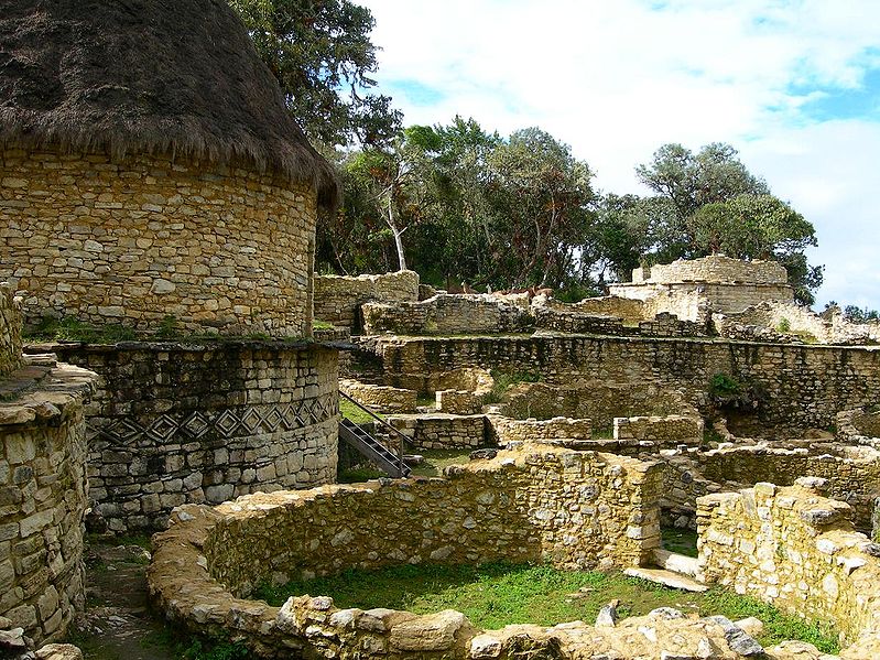
Chachapoyas, in northern Peru, is the land of the “Cloud People.” This is the cloud forest of eternal mist, high in the Andes, overlooking the Amazon Basin, hidden in a perpetual mist with orchids and bromeliads everywhere. Though the Peruvian government thinks this area has the potential to become the “Machu Picchu of the north,” it has not yet reached that level of popularity, mainly because there are no commercial flights to the main city, also called Chachapoyas.
The most famous ruin is Kuelap. This fortress is the largest stone structure of South America. It contains more than 450 stone houses, mostly circular. It is located on a mountain higher than Machu Picchu, at 9500 feet, and is older than the Inca Empire. It was started at around 800 A.D. and was occupied until about 1500 A.D. It’s outer wall is about 700-800 yards long and ranges from 35 to over 50 feet high.
There are many other unexcavated ruins on mountaintops in the area and new sites are always being found. Years ago, when I was hiking in the area with Dr. Peter Lerch, an officer from the Institute of Culture, he pointed to several mountaintops where you could faintly make out ruins. He knew they were there, but just hadn’t had time to investigate them because the only way to get to them was by foot or by horse. Once, when I was sending a group from Arizona to the area, my local operator told me that a new “lost city” had recently been discovered and wanted to know if my group would like to go there and be the first “gringos” to see the site. Naturally they said they would like to and it was one of the highlights of their trip.
Ruins of Chachapoya Dwellings [Dave Lonsdale, Flickr, CC BY 2.0]
There are several cliff tomb sites such as La Petaca. Revash and Diablo Huasi and other citadels, such as Tajopampa and La Joya. The Chachapoyans practiced mummification. Several were found in La Petaca and many were found in the ruins at Laguna de Los Condores, which was discovered in 1996. A museum was built in Leymebamba to house the remains of the mummies and other artifacts that were found in the area.
During the time of early empires in the Fertile Crescent, Mesopotamia, several civilizations rose and fell during intense warfare and failed development. These early territories contributed a vast amount of cultural evolution into their societies as they tried to prosper including, language, myth and, warfare. The Hittite Empire faced many hardships as it continued to grow within Mesopotamia, but continued to prosper and develop until its collapse.
The Hittite Monument of Sultanhani:
This stele was erected in the name of
god Tarhui for a better year of crops.
[Brewbooks CC BY-SA 2.0]
In the North West area of Mesopotamia a new culture and empire grew into the Hittite Kingdom. The stronghold and capital city of the Hittite empire was called Hattusas and laid in central Turkey. With the rise of the Hittite Empire also came the first record of the Indo-European language being spoken and with a bit of luck it became one of the strongest empires of its time. The Hittite language was written in cuneiform and during the end of the empires time frame the use of hieroglyphics became prevalent.
Since the Hittite Empire was so close in time frame and proximity to the Assyrian and Babylonian Empires many deities and myths are similar or even just different interpretations or accounts of the same event. The Hittites worshipped the Goddess Ishtar who held domain over war, fertility, love, and the dead. In the myth The Descent of Ishtar to the Underworld, the Hittites and surrounding cultures used the myth to reason the changing of the seasons through out the years.
The myth accounts that Ishtar went down to the underworld demanding entrance and threatening to raise the dead to kill the living. After her threats the gatekeeper goes to Ereshikigal to ask if Ishtar could enter. After being allowed entrance Ishtar is trapped in the underworld and winter comes over Mesopotamia. In a plea to let Ishtar leave the underworld Ea created a man named Good-looks and offered him to Ereshikigal. Out of outrage to Ea trick Ereshikigal curses Good-looks and reluctantly makes Ishtar leave the underworld restoring spring to the nations of Mesopotamia.
During a time when the Babylonian Empire was frail the King of Hittite was able to attack was able to attack the city of Babylon in the seventeenth century BC. Though the Hittites were unable to make a significant amount of headway in their campaign to conquer other areas of Mesopotamia they did contribute to the growth of Mesopotamia’s culture and diversity. Around 1200 BC the Hittite empire lost most of its power and by 1000 BCE it dissipated completely.
Italy has been home to technological advances and innovative ideas for hundreds of years. From Roman architecture to Italian fashion, Italy continues to grow and prosper despite the natural disasters and intense warfare attempting to set back its cultural progression. Through religious beliefs, cultural norms, archaeology, and architecture northern Italy has continue to prosper into the culturally diverse conundrum it is today.
The Roman Empire
The Roman mythology that most of us know of today that developed throughout Italy and eventually the Roman Empire had roots based in not only in the Greek mythology that was adapted through colonies in southern Italy, but had bases in Etruscan and other Latin tribes as well. The Roman Empire developed an intricate belief system as it became a religious sponge while it continued to conquer neighboring lands. As regional deities became accepted into mainstream Roman traditions (like the Phoenician Goddess Cybele and the Persian God Mithra) these new gods and goddesses received their own temples and priests.
The Roman Empire and the few parts of it that will be later known as Italy adopted another religious tradition during the Imperial system of including emperors as living gods. At first, this system was widely rejected by the people of the Roman Empire, but it eventually inte-grated itself within the empires religious prac-tices which would help religious and other fu-ture leaders when making controversial policies later on.
As Christianity began to develop a foothold in Roman culture, there was a huge clash be-tween the Roman Pantheon believers and the neophyte Christians. As the religious conflict shifted cultural norms of society completely and established a new way of life. There are still reminisces of the Roman Pantheon belief system present in Italian society, but the myths are not nearly as prevalent or seriously considered.
Households and Economic Growth
Culture in Northern Italy is not as agriculturally based as southern Italy. The continued development of technology was adapted into Northern Italy for the growth industrialization. Economy, in turn, altered many aspects of its cultural norm by shifting the focus of importance among idealizations within its citizens.
Within families it became important for children to become hard workers and not focus so much on family. With an emphasis on individual production becoming more prevalent in society not only did families become less centralized, but religious practices became less time consuming. Family still plays a large role in Italian culture, but when comparing northern and southern Italian culture there are obvious differences in the amount of time devotion that are placed on developing a strong family ties and becoming an individual producer within society. Religious rituals such as attending church or mass also become less significant. Many still practice the Catholic traditions or a different Christianity based faith, but no longer place importance on attendance and instead they focus on individually strengthening their faith.
Northern Italy is rich in archaeological dig sites from the intriguing Iceman to the city Luna - these sites provide evidence into the daily lives of Italian ancestors and the down fall of the Roman Empire. Since Italy has been home to different civilizations and nomadic people for so long it has many archaeological sites to study allowing the world to learn about its past.
The Iceman named Otzi was found in the Alps between Northern Italy and Austria. His stable isotopic signature suggests that he way born near a town that is now called Brixen. Otzi died around 5200 years ago, but his remains are perfectly preserved by the glacier he got trapped in, allowing new and interesting information to be revealed about the lifestyle of people during 3350-3300 BCE. His body shows evidence that he was most likely a Neolithic herder or pastoralist. Otzis’ body even displays tattoos including a cross on the inside of his left knee, parallel straight lines arranged in two rows on his back above his kidneys that are each about six inches long, and several parallel lines on his ankles. The end of his life was not peaceful at all, with evidence showing that his last two to three days were spent fighting for his life before he retreated to the mountains and died (Hirst, 2012).
Luna was a city under the Roman Empire's control during the 5th and 6th century. As such it provides strong evidence of Germanic attacks on the Roman Empire during its collapse and shows other factors as to its downfall. It is evident in Luna that the nearby quarry was abandoned, the aqueduct system was breaking down, and communal roads and buildings were no longer in use (Hirst, 2012).
As Christianity continued to rise through out Italy and the Roman Empire new architectural styles were developed in order to build churches and later on other important structures. There were Byzantine style churches that were set up using the Greek cross and had a very linear set up. They had a very open set up to allow more people to get in and used typically used large amounts of small to medium sized windows in order to let in an optimum amount of light. Inside the churches were decorated with mosaics and paintings that depicted bible stories such as the Resurrection of Christ and The Garden of Eden. Having art work inside the churches was essential because many people who were illiterate came to worship and the mosaics and paintings made the stories relate more to the masses.
Over time the Gothic style of building became more prevalent in building. Gothic style churches were built to be very tall and used large windows in order to flood the churches with light as if it were the light of heaven. As the Gothic style grew more complex stain glass windows were incorporated into the method. Instead of using large amounts of stone to build the churches and later on other important buildings, the Gothic style used thin columns along with patterns of ribs, pointed arches, and windows. As time went on the Gothic style continued to try and build taller and taller building. In Italy the Gothic style was very unique. The Florence Cathedrals’ exterior is made to look like the Romanesque octagonal baptistery. While the inside uses pointed arches in order to create measured space in its enormous dome like size.
Church of San Rufino [left] and Basilica of Saint Clare [right] [Randy OHC, CC BY 2.0]
Sayre, Henry M. "Chapter 17 The Ancient World: Roman Art." A World of Art. Boston: Prentice Hall, 2012. pp. 431-438. Print. ISBN 987-0-205-88757-6
Schifini D'Andrea, Silvana. "Italian Quality of Life." Social Indicators Research, Vol. 44, No. 1, Studies on the Quality of Life in Italy (May, 1998), pp. 5-39 [Published by: Springer Article Stable URL: http://www.jstor.org/stable/27507548]
Contribution by: Margaret Smith, University of New Mexico, Anthropology & Japanese undergraduate
Welcome to BermudaQuest, a free online journal primarily about Archaeology, Ancient History, and stories about different cultures from around the world.
Founded by Melanie E Magdalena, BermudaQuest and Origins (our magazine) have over a million readers! We would love to include your insight, experience, photos, and thoughts about your culture, heritage, and travels. Make sure you check out Origins, with over 4 million readers!
WE'VE MOVED!
Please join our new page! Origins Scientific Research Society now operates BermudaQuest! Please bookmark www.knowyourorigins.org
Explore! by Origins has all of our posts here and all the newest content! We look forward to seeing you on our new and improved site made for our wonderful readers.


.jpg)